A Bilingual User’s Guide for the Decision SupportTool for Managing Re-Vegetation and its Impact onHydrology (ReVegIH) in the Coarse Sandy HillyCatchments of the Loess Plateau, China
|
|
|
- 眉笈 毛
- 5 years ago
- Views:
Transcription

 in")


1 A Bilingual User s Guide for the Decision Support Tool for Managing Re-Vegetation and its Impact on Hydrology (ReVegIH) in the Coarse Sandy Hilly Catchments of the Loess Plateau, China LingTao Li, Tim R. McVicar, Tom G. Van Niel, Lu Zhang Rui Li, QinKe Yang, XiaoPing Zhang, XingMin Mu, ZhongMing Wen, WenZhao Liu, Yong'An Zhao, ZhiHong Liu CSIRO Land and Water Technical Report 19/05
2 植被恢复布局及其水文效应评价支持工具 ( 中英文 ) A Bilingual User s Guide for the Decision Support Tool for Managing Re-Vegetation and its Impact on Hydrology (ReVegIH) in the Coarse Sandy Hilly Catchments of the Loess Plateau, China 李领涛, 蒂姆 麦克维加, 汤姆 范 尼尔, 张橹李锐, 杨勤科, 张晓萍, 穆兴民, 温仲明, 刘文兆, 赵永安, 刘志红 LingTao Li, Tim R. McVicar, Tom G. Van Niel, Lu Zhang Rui Li, QinKe Yang, XiaoPing Zhang, XingMin Mu, ZhongMing Wen, WenZhao Liu, Yong An Zhao, ZhiHong Liu 2005 年 12 月澳大利亚联邦科工组织水土资源研究所技术报告 CSIRO Land and Water Technical Report 19/05 December 2005

3 Copyright CSIRO and ISWC. To the extent permitted by law, all commercial rights are reserved and no part of this publication covered by copyright may be reproduced or copied in any form or by any means for any commercial purpose. Permission is granted for any copyright material contained in this publication to be used for any non-commercial purpose which will assist the distribution, promotion or use of the ReVegIH application. Important Disclaimer: The copyright owners advise that the information contained in this publication comprises general statements based on scientific research. The reader is advised and needs to be aware that such information may be incomplete or unable to be used in all specific situations. No reliance or actions must therefore be made on that information without seeking prior expert professional, scientific and technical advice. To the extent permitted by law, the copyright owners (including their employees and consultants) exclude all liability to any person for any consequences, including but not limited to all losses, damages, costs, expenses and any other compensation, arising directly or indirectly from using this publication (in part or in whole) and any information or material contained in it. 注意 :ReVegIH 是个一般性的 区域水平的指导性模型工具, 并不能完整 准确地提供每个植被恢复区的详细情况 在任何植被恢复行动前, 一定要考察当地实际情况, 对乔灌草的适宜性和品种选择须听取有关专家的独立意见 决不能单单依赖 ReVegIH 的模型结果 Warning: ReVegIH is a general modelling tool that provides strategic guidance at the regional level only. Operationally it does NOT provide 100% accurate, detailed or complete information for each potential re-vegetation area. Before you commence any re-vegetation activities, you must ALWAYS check that the results correspond with on-the-ground conditions. You must NOT act, nor rely, on the results of ReVegIH without seeking confirmation from an independent expert regarding the suitability and use of trees and shrubs for each particular re-vegetation area. Authors: LingTao Li a, Tim R. McVicar a, Tom G. Van Niel a, Lu Zhang a, Rui Li b, QinKe Yang b, XiaoPing Zhang b, XingMin Mu b, ZhongMing Wen b, WenZhao Liu b, Yong An Zhao b, ZhiHong Liu b a CSIRO Land and Water, GPO Box 1666, Canberra, 2601, ACT, Australia Tel.: , lingtao.li@csiro.au and tim.mcvicar@csiro.au b Institute of Soil and Water Conservation (ISWC), Chinese Academy of Sciences, 26 Xinong Road, Yangling, Shaanxi Province, China. Tel: lirui@ms.iswc.ac.cn and qkyang@ms.iswc.ac.cn Cover: The main photograph shows a typical landscape of the Coarse Sandy Hilly Catchments of the Loess Plateau, China. Severe gullying is present, some of which almost reaches the ridges. In efforts to reduce erosion rates large areas have been re-vegetated, as the photo shows, though this has also reduced the runoff. Summer cropping is conducted on the terraces and extensive grazing of sheep takes place over all parts of the landscape. Photo taken by XianMo Zhu near Yan an City, Shaanxi Province, May The bottom left insert shows a worker tending 5-year-old pines in Pianguan County, Shanxi Province, 7th October 2004; photo by Tim McVicar. The top right insert shows the graphic user interface of the ReVegIH application. For bibliographic purposes, this document may be cited as: Li, L.T., McVicar, T.R., Van Niel, T.G. Zhang, L., Li, R., Yang, Q.K., Zhang, X.P., Mu, X.M., Wen, Z.M., Liu, W.Z., Zhao, Y.A. and Liu, Z.H. (2005) A Bilingual User s Guide for the Decision Support Tool for Managing Re-Vegetation and its Impact on Hydrology (ReVegIH) in the Coarse Sandy Hilly Catchments of the Loess Plateau, China. CSIRO Land and Water Technical Report 19/05, Canberra, Australia, 48 pp. A PDF version is available at: ISBN CSIRO Land and Water Page ii
4 目录 Table of Contents 致谢 Acknowledgements... iv 内容摘要 Executive Summary... vii 1. 简介 Introduction 数据描述 Data acquisition and description 系统流程 System flow chart 软件介绍 Software Description 系统设计思路 System design considerations 基本要求 Essential requirements 实现方法 Methodology of implementing requirements 用户界面介绍 The ReVegIH graphical user interface (GUI) 菜单区 Menus (A) 地图显示区 Display area (B) 工具选择 Toolbar (C) 模型结果显示区 Modelling output area (D) 区域划分方式 Mapped by (E) 显示地图 Show dataset (F) 植被恢复适宜区 Target level settings (G) 鼠标所在区域的相关信息 Information of mouse over region (H) 模式显示 Mode status bar (I) 系统要求 System requirements 使用 Using ReVegIH 安装 卸载与运行 Installing, uninstalling and running 安装 Installing ReVegIH 启动 Starting ReVegIH 退出 Exiting ReVegIH 卸载 Uninstalling ReVegIH 使用 Working with ReVegIH 显示地图 Displaying datasets 打开 / 关闭显示信息选项 Toggle show information option 显示信息 Viewing information 选择区域 Selecting and unselecting a county/catchment 地图缩放 Zooming and panning maps 模式转换 Changing modes 土地利用变化模拟 Simulating landuse change 软件支持及其它 Support and Other Issues 问题解答 Trouble shooting 常见问题 Common troubles 支持 Support and questions 参考文献 References CSIRO Land and Water Page iii
5 致谢 Acknowledgements 本项工作由澳大利亚国际农业研究中心项目 ( 区域植被恢复的水环境效应研究, LWR/2002/018) 资助, 中国科学院知识创新方向项目 ( 黄土高原水土保持的区域环境效应, KZCX3-SW-421) 也提供了部分资助 感谢联邦科学与工业研究组织水资源研究所组的 Harold Hotham, Joel Rahman, Shane Seaton and Ben Leighton 在软件开发中所给予的帮助 许多管理干部和专业人员对该工具的最后成型提出了宝贵的意见和建议, 谨此致以谢意 他们包括 : 黄河水利委员会土壤保持局刘正杰处长 (2003 年 8 月 14 日,2004 年 10 月 日和 2005 年 10 月 26 日 ) 黄河上中游管理局计划处王俊峰处长 (2003 年 8 月 14 日,2004 年 10 月 日和 2005 年 10 月 26 日 ) 黄河水利委员会土壤保持局王文善处长 (2004 年 10 月 日和 2005 年 10 月 26 日 ) 黄河水利委员会水文局徐建华总工 (2004 年 10 月 日和 2005 年 10 月 26 日 ) 黄河上中游管理局郑新民总工 (2003 年 8 月 14 日和 2005 年 10 月 26 日 ) 黄河水土保持绥德治理监督局郑宝明局长 (2004 年 10 月 8 日和 2005 年 10 月 26 日 ) 黄河水土保持绥德治理监督局王晓局长 (2004 年 10 月 8 日 ) 黄河水土保持绥德治理监督局白志刚主任 (2004 年 10 月 8 日 ) 黄河水土保持绥德治理监督局田永宏主任 (2004 年 10 月 8 日 ) 黄委会丁家沟水文站马如江站长 (2004 年 10 月 8 日 ) 黄委会晋陕蒙接壤区水土保持监督局蔺明华局长 (2004 年 10 月 6 日和 2005 年 10 月 26 日 ) 黄委会晋陕蒙接壤区水土保持监督局监督处尹增斌处长 (2004 年 10 月 6 日 ) 榆林市榆央区水利水保局胡宏飞局长 (2004 年 10 月 6 日 ) 西北植物研究所徐朗然教授 (2004 年 10 月 4 日到 9 日,2005 年 10 月 26 日 ) 安塞县县政府副县长高树杰 (2005 年 10 月 28 日 ) 安塞县政府办主任高生强 (2005 年 10 月 28 日 ) 安塞县农业局局长张俊峰 (2004 年 10 月 5 日,2005 年 10 月 26 日和 28 日 ) 安塞县林业局局长白寒 (2005 年 10 月 28 日 ) 安塞县水利局局长王塞红 (2005 年 10 月 28 日 ) 安塞县沿河湾镇政府副镇长白冬芹 (2005 年 10 月 28 日 ) 延河治理办公室高峰 (2005 年 10 月 28 日 ) 感谢 Ian Willett 博士对该工具付出的帮助, 感谢两位课题验收专家 Joe Walker 博士和李靖教授在课题终审时所给于的积极建议 课题组还感谢 Heinz Buettikofer 先生的 CD 封面设计,Fred van Dijk 先生在版权等法律方面文字的工作 This research was supported by the Australian Centre for International Agricultural Research (ACIAR) project titled Regional impacts of re-vegetation on water resources of the Loess Plateau, China and the Middle and Upper Murrumbidgee Catchment, Australia CSIRO Land and Water Page iv
6 (LWR/2002/018), CSIRO Land and Water, and the Chinese Academy of Sciences and Ministry of Water Resources Institute of Soil and Water Conservation (ISWC) based in Yangling. This project was also supported, in part, by the Chinese Academy of Sciences Knowledge Renovation Project KZCX3-SW-421. LWR/2002/018 was an Associate Project of the Cooperative Research Centre for Catchment Hydrology that merged with the Cooperative Research Centre for Freshwater Ecology to become the ewater Cooperative Research Centre from 1 July Sincere thanks to Harold Hotham (who coded a very early prototype of the application that was demonstrated in August 2003), Joel Rahman, Shane Seaton and Ben Leighton from the CSIRO Land and Water TIME (The Invisible Modelling Environment) team for their invaluable help in developing the software. Thanks to the many stakeholders who provided ideas about the final form of the application. They are listed below with family names bolded (and the dates they attended project meetings are provided in parenthesis): 1. Mr Zhengjie Liu, Director, Soil Conservation Bureau Section, Yellow River Conservation Commission, Zhengzhou, Henan Province (14 Aug. 2003, 13 and 14 Oct and 26 Oct. 2005); 2. Mr Junfeng Wang, Director, Planning Section, Bureau of the Upper and Middle Reaches of the Yellow River Committee, Xian, Shaanxi Province (14 Aug. 2003, 13 and 14 Oct and 26 Oct. 2005); 3. Mr Jianhua Xu, Chief Engineer, Hydrology Bureau, Yellow River Conservation Commission, Zhengzhou, Henan Province (13 and 14 Oct and 26 Oct. 2005); 4. Mr Wenshan Wang, Director, Soil Conservation Section, Yellow River Conservation Commission, Zhengzhou, Henan Province (13 and 14 Oct and 26 Oct. 2005); 5. Mr Xinmin Zheng, Chief Engineer, Bureau of the Upper and Middle Reaches of the Yellow River Committee, Xian, Shaanxi Province (14 Aug and 26 Oct. 2005); 6. Mr Baoming Zheng, Director, Suide Bureau of Yellow River Soil and Water Conservation and Supervision, Suide, Shaanxi Province (8 Oct and 26 Oct. 2005); 7. Mr Minghua Lin, Director, Bureau of Soil and Water Monitoring of Shanxi-Shaanxi-Inner Mongolia Triangle of Yellow River Conservation Commission, Yulin, Shaanxi Province (6 Oct and 26 Oct. 2005); 8. Prof. Langran Xu, North-Western Institute of Botanic Research, Yangling, Shaanxi Province (4 to 9 Oct and 26 Oct. 2005); 9. Mr Junfeng Zhang, Director, Bureau of Agriculture of Ansai County, Ansai, Shaanxi Province (5 Oct and 26 and 28 Oct. 2005); 10. Mr Zengbin Yin, Deputy Director, Bureau of Soil and Water Monitoring of Shanxi-Shaanxi-Inner Mongolia Triangle of Yellow River Conservation Commission, Yulin, Shaanxi Province (6 Oct. 2004); 11. Mr Hongfei Hu, Director, Bureau of Soil and Water Conservation, Yuyang, Yulin, Shaanxi Province (6 Oct. 2004); 12. Mr Xiao Wang, Deputy Director, Suide Bureau of Yellow River Soil and Water Conservation and Supervision, Suide, Shaanxi Province (8 Oct. 2004); 13. Mr Zhigang Bai, Manager, Suide Bureau of Yellow River Soil and Water Conservation and Supervision, Suide, Shaanxi Province (8 Oct. 2004); 14. Mr Yonghong Tian, Manager, Suide Bureau of Yellow River Soil and Water Conservation and Supervision, Suide, Shaanxi Province (8 Oct. 2004); 15. Mr Rujiang Ma, Director, Dingjiagou Hydrology Station of Yellow River Conservation Commission, Suide Shaanxi Province (8 Oct. 2004); CSIRO Land and Water Page v
7 16. Mr Shujie Gao, Deputy Governor of Ansai County, Ansai, Shaanxi Province (28 Oct. 2005); 17. Mr Saihong Wang, Director, Bureau of Water Resources of Ansai County, Ansai, Shaanxi Province (28 Oct. 2005); 18. Mr Shengqiang Gao, Manager, General Administration Office of Ansai Government, Ansai, Shaanxi Province (28 Oct. 2005); 19. Mr Han Bai, Director, Bureau of Forestry of Ansai County, Ansai, Shaanxi Province (28 Oct. 2005); 20. Mrs Dongqin Bai, Deputy Head of Yanhewan Township, Ansai County, Ansai, Shaanxi Province (28 Oct. 2005); and 21. Mr Feng Gao, Yanhe River Management Office, Ansai County, Ansai, Shaanxi Province (28 Oct. 2005). Thanks also to Dr Ian Willett for providing input to ReVegIH, and to our two external reviewers Dr Joe Walker and Prof. Jing Li for making many positive suggestions during our final review. Finally the entire project team offers a warm thanks to: (1) Mr Heinz Buettikofer (CSIRO Land and Water Graphic Communicator notre graphiste avec virtuosité ) for ably working with both English and Chinese text to design the cover for this report and for the accompanying ReVegIH CD, and (2) Mr Fred van Dijk (CSIRO Land and Water Legal Commercial Officer noster egregius iurisconsultus ab accipiter-acies ad pertractatio ) for providing assistance with wording of disclaimers, copyrights and the licence of use for the ReVegIH application. CSIRO Land and Water Page vi
8 内容摘要 Executive Summary 恢复植被是防治黄土高原水土流失问题的主要措施之一, 恢复植被对区域水文的影响不容忽视 事实上, 减少水土流失的同时, 因为蒸发蒸腾作用和入渗的加强, 大规模的恢复植被也减少了地表径流量 定量评价这种影响是澳大利亚国际农业研究中心课题 LWR/2002/018 的主要研究目的 作为课题成果之一, 该软件将给有关部门和管理人员提供空间情景模拟工具, 更好地治理环境 它可以模拟林地覆盖率改变所引起的径流变化, 直观而迅速 ; 也确定了适合植被恢复的地区以及优先植树区范围, 并提供了 38 种植被的空间适宜性 该软件在微软.NET 下使用 C# 语言编程 利用了 TIME ( 隐性建模环境 - The Invisible Modelling Environment) 组件 不需要其它地理信息系统软件的支持 降雨 - 径流运算采用的模型由澳大利亚联邦科工组织水资源所张橹博士等人开发, 张晓萍根据研究区具体情况进行了改进 In order to reduce the massive soil erosion in the113,000 km 2 Coarse Sandy Hilly Catchments (CSHC) of the Loess Plateau, China, vast expanses of land have been, or are planned, for re-vegetation with deep-rooted perennial species. This re-vegetation process will not only result in less soil erosion in the CSHC, but also less runoff due to increased evapotranspiration (ET). The impact on surface hydrology has, until now, been largely ignored in the implementation of the re-vegetation policy, even though water is a critical resource driving food security in support of the hundreds of millions of people in the region. To address this issue, the Australian Centre for International Agricultural Research (ACIAR) Project LWR/2002/018 was developed to further understand this regional eco-hydrologic process and most importantly, to provide mid to senior policy makers and soil and water managers at national, regional and local scales of governance with information to make better decisions. This technology transfer is primarily performed through a bilingual software application called Re-Vegetation Impacts on Hydrology (ReVegIH). This report describes the various options and datasets available in ReVegIH and provides a guide to its users. ReVegIH, which was developed in Microsoft s.net environment using C# calling some TIME (The Invisible Modelling Environment) functions, is a stand alone application that provides basic Geographical Information System (GIS) functions so users do not need to install proprietary GIS software. The application provides a spatial scenario modelling capability for stakeholders to better manage their environment. ReVegIH provides managers and both decision and policy makers access to an eco-hydrological modelling capacity at 100 m resolution and to maximise usability, all required datasets are packaged as part of ReVegIH. Through the application, users can estimate impacts of different re-vegetation schemes on runoff and ET in the CSHC by selecting either 1 of the predefined 42 catchments or 1 of the 70 predefined counties that contribute to the CSHC. The underlying annual average rainfall-runoff model used in ReVegIH was originally developed by CSIRO Land and Water using a global dataset and it has been calibrated locally for the CSHC. The model partitions long-term annual average precipitation into annual average ET and annual average runoff as a function of percentage woody perennials in a catchment. Additionally, CSIRO Land and Water Page vii
9 over the entire CSHC (and for any selected catchment or county) users can spatially identify (at 100 m resolution) re-vegetation target areas, priority areas and the suitability of planting conditions for 38 vegetation species, both trees and shrubs; fruit trees that may provide additional economic returns to farmers are also identified. The hydrologic impact of selecting any combination of target (or priority) re-vegetation areas limited by current landuses is also modelled on a catchment or county basis. Re-vegetation priority areas are those cells located in a target area that are both lower than and adjacent to steep slopes and gullies. The combined effect of re-planting the priority zones first will be that the water loss will be minimised while maximising the reduction of soil entering the river network. ReVegIH provides the ability to view one raster dataset while gaining information from another. For example, we anticipate that the predominant use of ReVegIH will be to display the revegetation dataset (showing the target level/priority area in combination with two pre-defined land-limits) while overlaying and exploring information of vegetation suitability for the 38 species. Using ReVegIH in this manner provides users with: (1) a spatial assessment (at a 100 m resolution) of where to, and where not to, re-vegetate with perennial species; (2) seven different site suitability mapping options from the list of 38 species; and (3) estimation of re-vegetation scenario s impact on regional hydrology. The project team recommend that some detailed site assessment be undertaken prior to performing any re-planting as ReVegIH is a regional scale decision support tool, and local factors (near and below the resolution of the data used in the application) may be critical in determining success (or failure) of re-vegetation schemes. CSIRO Land and Water Page viii
10 1. 简介 Introduction 恢复植被是防治黄土高原水土流失问题的主要措施之一, 恢复植被对区域水文的影响不容忽视 事实上, 减少水土流失的同时, 因为蒸发蒸腾作用和入渗的加强, 大规模的恢复植被也减少了地表径流量 定量评价这种影响是澳大利亚国际农业研究中心课题 LWR/2002/018 的主要研究目的 研究区位置如图 Figure 1 所示 这个软件是课题成果之一, 希望给有关部门和管理人员提供空间情景模拟工具, 以方便环境保护和水土流失治理的管理和决策 这有两个方面 : 第一是模拟林地覆盖率改变所引起的径流变化, 直观而迅速 ; 第二是确定了适合植被恢复的地区以及优先植树区范围, 并提供了 38 种植被的空间适宜性 该软件在微软公司的.NET 下使用 C# 语言编程 利用了 TIME ( 隐性建模环境 - The Invisible Modelling Environment) 组件 不需要其它地理信息系统软件的支持 降雨 - 径流运算采用的模型由澳大利亚联邦科工组织水资源所张橹博士等人开发, 张晓萍根据研究区具体情况进行了改进 见下面的公式 1 其中 w 的确定见 (Zhang et al. 2006) To reduce environmental degradation, the Chinese Central Government established the National Forest Protection Project (NFPP) which aims to halt the destruction of natural forests (Ye et al. 2003). Under the umbrella of the NFPP the Grain for Green (Tui Geng Huan Lin) project was established to return cultivated land with slopes of 25 or more to perennial vegetation (e.g., Ke and Zhou 2005; Wenhua 2004; Winkler 2002; Xu et al. 2004; Yang 2004; Ye et al. 2003). Since 1999 as part of the Grain for Green project (or Sloping Land Conversion Program, Xu et al. 2004) over 7 million ha have been re-vegetated, with 5.9 million ha being converted in 2002 and 2003 (Xu et al. 2004). The Loess Plateau is one of the hot-spots of environmental degradation in China; erosion rates ranging from 20,000 to 30,000 t.km -2.year -1 are commonly reported (e.g. Xiang-zhou et al. 2004) with extremely high rates (59,700 t.km -2.year -1 ) also being documented (Shi and Shao 2000). The high erosion rates from the Loess Plateau mean that in the lower reaches of the Yellow River (i.e., on the North China Plain 图 Figure 1) the bottom of the river bed is, in places, 20 m above the surrounding land surface (Li 2003); about 25% of the sediment load is deposited on the river bed resulting in an increase of river bed height by 8 to 10 cm annually (Douglas 1989; Shi and Shao 2000). Large-scale re-vegetation is widely acknowledged as a primary solution to the severe soil erosion existing in the Coarse Sandy Hilly Catchments (CSHC see 图 Figure 1). CSIRO Land and Water Page 1
11 图 Figure 1. 研究区以及黄土高原位置示意图 The inset map shows the location of the 623,586 km 2 Loess Plateau (dark shading) and the North China Plain (lighter shading) on the middle and lower reaches of the Yellow River, respectively. The Loess Plateau supports a population of 82 million people (Xiubin et al. 2003). The main map shows the location of the 112,728 km 2 Coarse Sandy Hilly Catchments (CSHC). Positive impacts of such re-vegetation schemes include: (1) stabilising the soil matrix hence reducing erosion (Xiubin et al report reductions of erosion rates ranging from 40 to 90%); (2) reducing peak-flow after storm events (Huang and Zhang 2004 hence reducing the risk of average (not extreme) flooding; Wei et al. 2005); (3) sequestering carbon to offset China s booming economic growth and subsequent energy usage (Byrne et al. 1996; Foster 2001) ; and (4) providing habitat and biodiversity security (Jiang et al. 2003; Xu et al. 1999). Note the effectiveness of reducing peak-flow after storm events requires an assessment of event- and site-specific factors (Calder 1999). For example, re-vegetation will have minimal (to no) impact on reducing peak-flows (and hence controlling floods) when precipitation rates are extremely high (as in a 1:100 year 24-hour storm event). A counter to these positive impacts is the potentially more negative (and sometime forgotten) reduction in annual runoff due to increased evapotranspiration (ET) associated with the re-vegetation schemes (Huang and Zhang 2004; Wei et al. 2005; Xiubin et al. 2003). Given that: (1) approximately 43% of the annual runoff to the Yellow River Basin is generated from the middle reaches of the Yellow River (draining the Loess Plateau from Lanzhou to Sanmen, 图 Figure 1, Li 2003; Xiubin et al. 2003); and (2) water resources are scarce in the Yellow River Basin (due to increasing competition arising from rapid industrialisation of the economy and urbanisation of the population e.g., Anderson and Peng 1998; Brown and Halweil 1998; Paarlberg 1997; CSIRO Land and Water Page 2
12 Rosegrant and Ringler 2000; Varis and Vakkilainen 2001; Xu et al. 2002), any reduction of runoff from the Loess Plateau is a serious concern for the 107 million people living in the Yellow River Basin and for the 400 million living on the North China Plain partly relying on its water. The aims of ACIAR Project LWR/2002/018 are: (1) to further understand the regional ecohydrology of the CSHC; and (2) to provide mid to senior policy makers and soil and water managers with the information they need to make better decisions (McVicar 2002). A major project output is the bilingual software application called Re-Vegetation Impacts on Hydrology (ReVegIH) that provides spatial scenario modelling capabilities for stakeholders to better manage the environment. It does the job in two ways: first, it simulates impacts of different re-vegetation schemes on runoff and ET; secondly, it identifies re-vegetation target and priority areas for trees and shrubs and maps the suitability of 38 perennial species for planting in the CSHC. The best-practice CSHC meteorological and geographical datasets are provided as base data in ReVegIH. As a stand alone application, ReVegIH provides basic Geographical Information System (GIS) functions so users do not need to install expensive proprietary GIS software. ReVegIH is developed in Microsoft s.net environment using C# and it calls some TIME (The Invisible Modelling Environment; Rahman et al. 2003; Rahman et al. 2004) functions. TIME (also developed in.net) is a model developing environment which supports advanced applications developed using programming languages such as C#, Visual Basic, and C++. The rainfall-runoff algorithm (Equation 1) used in ReVegIH is a locally calibrated version (Zhang et al. 2006) of the generalised model developed using a global dataset by CSIRO Land and Water (Zhang et al. 2001). E0 E W ET = P f P + ( 1 f ) P (Equation 1) E 0 P E0 P W + P E0 P E0 Where ET: average annual actual evapotranspiration (mm year -1 ); P: average annual precipitation (mm year -1 ); f: % forest cover; E 0: average E pan (mm year -1 ); and W: plant-available water coefficient. Zhang et al. (2006) developed a two-step process to model W for a catchment (or county). This modelling minimises the difference between the average annual modelled (or simulated) runoff and average annual measured (or observed) runoff for 36 hydrology stations located throughout the CSHC. In the framework of Zhang et al. (2001) it is assumed that there are no long-term changes in soil storage and using equation 1 to calculate average annual ET with the average annual runoff being calculated as the residual between average annual P CSIRO Land and Water Page 3
13 minus average annual ET. The averages are calculated from 21 years of data, recorded between 1980 and 2000; see McVicar et al. (2005) for full details. Following the convention of Zhang et al. (2001), and acknowledging that the CSHC is located in a dry area (with measured average annual runoff usually being less than 10% of the average annual precipitation) we calculate a modified plant-available water coefficient W using spatially average data from the 100 m grids for each catchment (or county) with the following equation: W = x (1-f_current) x (DI 2 ) where the dryness index, DI = E 0 / P and f_current is the current percent forest landuse for the catchment (or county). In the modelling conducted here the term forest cover includes forest, sparse forest and shrubland, and this is referred to as percent woody cover (meaning deep-rooted perennial vegetation whose water requirements are different from grasses) in the remainder of this guide. The value of W was calculated using spatially averaged conditions for each catchment (or county) and then the value of W was derived from W as follows: 0.80 <= W, W = <= W < 0.80, W = 0.45 W < 0.25, W = 0.10 The resulting W is then used in equation 1 for the catchment (or county) for all values of simulated percent woody area. For 36 hydrology stations in the CSHC results of locally calibrating the global model are shown in 图 Figure 2. The locations and quality control of these hydrological data are provided in Li et al. (2005), and for full details regarding the model calibration to local CSHC conditions see Zhang et al. (2006) (a) (b) Modeld evapotranspiration (mm) y = x R 2 = Modeld runoff (mm) y = x R 2 = Actual evapotranspiration (mm) Actual runoff (mm) 图 Figure 2. 多沙粗沙区 36 个水文站的降雨 - 径流模型结果 (a) 年均实际蒸发蒸腾总量 (b) 年均径流 Model outputs for the 36 hydrology stations in the CSHC for (a) average annual actual evapotranspiration; and (b) average annual runoff. CSIRO Land and Water Page 4

![model [DEM], see 图 Figure 3) and two vector datasets (catchment boundaries and county boundaries); they are described below in turn.](/docs-images/90/102781039/images/14-1.jpg "(a) (b) (c) (e) (d) 图 Figure 3.")
 landuse/land cover; (b) re-vegetation area; (c) vegetation suitability; (d) precipitation and (e) DEM.")
 they must zoom in.")
14 1.1. 数据描述 Data acquisition and description 本软件使用的数据包括土地利用图 植被适宜性图 植被恢复适宜区图 多年平均降水量图 数字高程模型 多沙粗沙区流域界限图和县界图 The data used in ReVegIH include five raster datasets (landuse/land cover, re-vegetation areas, vegetation suitability, precipitation and digital elevation model [DEM], see 图 Figure 3) and two vector datasets (catchment boundaries and county boundaries); they are described below in turn. (a) (b) (c) (e) (d) 图 Figure 3. 显示不同地图时的屏幕抓图 (a) 土地利用图 ;(b) 植被恢复适宜区图 ;(c) 植被适宜性图 ;(d) 降雨量图 ;(e) 数字高程模型 The five raster datasets distributed with ReVegIH are displayed, they are: (a) landuse/land cover; (b) re-vegetation area; (c) vegetation suitability; (d) precipitation and (e) DEM. With (b) and (c) having 100 m resolution, whereas (a), (d) and (e) provide context and thus have 500 m resolution. For users to see the priority areas in (b) they must zoom in. For (c) the legend represents the number of unique vegetation suitability combinations resulting from binary compression, this is unpacked to show specific species suitability. CSIRO Land and Water Page 5
15 1. 土地利用图 : 系由沈洪泉主编的 1986 年黄土高原 1:500,000 土地利用图 (Shen 1991) 重新分类而成 基本的 8 种类型见表 Table 1 用于植被恢复研究的各流域 县区的林地面积和土地限制数据 ( 基本农田 水体和居民地 ) 由此图提取 在张橹等的模型 (2001) 里, 林地包括了此表中的林地 疏林地和灌木林地 Landuse/Land Cover dataset: the original data were provided by the Institute for Soil and Water Conservation (ISWC), China for the whole Loess Plateau for 1986 at a scale of 1:500,000 (Shen 1991). The original vector format data were converted to raster data with a cell size of 100 m which is used for all the regional hydrological modelling in ReVegIH, with this data then being oversampled to 500 m resolution for display purposes only. This dataset contains eight primary classes (see 表 Table 1 below). The percentage woody cover for each area (either a catchment or a county in ReVegIH) and land limits data (highly productive agricultural land, water and urban), which are used in the re-vegetation scheme, are extracted from this data. We followed the model construct of Zhang et al. (2001) in our simulation modelling the classes of forest, sparse forest and shrublands have been aggregated to a perennial woody vegetation class. The 1986 percentage woody cover for each area defines the current conditions and is the benchmark from which all scenario modelling is compared. 表 Table 1. 8 种土地利用类型 The eight classes used in the CSHC landuse/land cover dataset, and the aerial extent they each occupy, are shown. 土地利用类型编码 Landuse/ Land Cover class code 土地利用类型名称 Class name 土地利用类型名称 Class name 所占比例 % of CSHC 1 农地 Agricultural land 林地 Forest 疏林地 Sparse forest 灌木林地 Shrubland 草地 Pasture 居民及建筑用地 Urban 水体 Water 未利用地 Barren 植被恢复适宜区图 : 即适于恢复植被的地方, 由两部分构成 : 植被恢复等级和土地限制类别 植被恢复等级是该地方适宜于植树种草的程度 分三个等级 : 一级表明适宜种植乔木, 二级表明适宜种植灌木, 三级表明宜于种草 通常来说, 可以种树的地方, 灌木 草本也可以种植 ; 可以种植灌木的地方, 草本也可以种植 土地限制是指处于植树区内部但不包含在造林规划中的土地 有两种组合类型 : 水体 居民地和林地, 称 WUF; 水体 居民地 林地和基本农田, 称 WUFA 另外, 用户可以查看植被优先恢复区域 在地图上, 植被优先恢复区域是植被恢复适宜区内紧邻极陡坡但海拔低于任一个相邻极陡坡栅格的一个栅格 ; 在地面上, 就是极陡坡下缘延坡面纵深 100 米的条带 该地带的绿化可以拦截并利用上方陡坡地流下来的水和土壤, 增加土壤水分供应, 促进植被生长, 有效地减轻水土流失 当经费或人力等不能满足所有适于恢复植被的地方时, 应优先恢复该地区的植被 CSIRO Land and Water Page 6
16 植被恢复适宜区图的编制考虑了地形部位 坡度 坡向和降雨因素 (Wen et al. 2005), 其中地形部位 坡度和坡向系由多沙粗沙区的 DEM 提取 Re-vegetation area dataset: this dataset spatially defines (at 100 m resolution) where the recommended areas are for re-vegetation. It consists of two parts: the target level and the land limit type. Target level: The delineation of target levels takes into account land position, slope, aspect and precipitation. Three target levels were defined which correspond to three vegetation growth forms: level 1 is where trees can grow well; level 2 is where shrubs can grow well; and level 3 is where grasses can grow well. It is understood that shrubs and grasses can also grow in areas suitable for trees (i.e., in level 1 areas); likewise, grasses can also grow in areas suitable for shrubs (i.e., in level 2 areas). The term target area is used in this report to represent the area associated with a specific user-defined target level. Land position (Wen et al. 2005), slope and aspect information are all derived from the CSHC DEM, with slope and aspect calculated in ArcGIS. In addition, within the selected target level users can view priority areas for re-vegetation. Re-vegetation priority areas first rely upon defining steep slopes where soil erosion potential is high and where the slopes are too steep for vegetation to grow well or for effective planting of vegetation using common methods. These steep slopes and gullies (SSG) are areas with slopes 15 from horizontal using the 100 m resolution DEM. Re-vegetation priority areas are those cells located in a target area that are both lower than and adjacent to a SSG boundary cell, see 图 Figure 4. Due to the cell size of the datasets, this means that priority areas are 100 metre wide zones downhill from the highly erodable SSG areas. In general, re-vegetation of these areas would have the most significant impact on intercepting and utilising soil and water coming from upslope. The combined effect of re-planting the priority zones first will be that the water loss will be minimised while maximising the reduction of soil entering the river network. If funds are available, the entire target area could be revegetated. Alternately, if this is not feasible, re-vegetation should be carried out first in the priority zones within these target areas. CSIRO Land and Water Page 7

17 图 Figure 4. 极陡坡 适宜植树区和优先植树区空间位置示意 Shows the conceptual spatial relationships of steep slope and gullies (SSG), re-vegetation target and revegetation priority areas. The top portion is a cross-sectional view of a typical gullied landscape of the CSHC, whereas the lower portion provides a planar view that is shown when using ReVegIH. Land limit type: Certain land uses or land cover types, by definition, do not permit revegetation, such as water bodies, urban regions, and already existing woody areas. Likewise, although possible, it is unadvisable to re-vegetate highly productive agricultural land that is vital in providing food for locals. Therefore, these four landuse types were termed land limits, meaning that the land that they cover can not be considered for re-vegetation. We have defined two land limits: the first consists of water, urban and forests (called WUF) areas; and the second consists of water, urban, forests and agricultural land (called WUFA). Note for WUF and WUFA the forest class represents perennial woody vegetation comprised of the forest, sparse forest and shrubland classes as introduced in the Landuse/Land Cover dataset above. Here we maintain calling it forest to better summarise the major historical revegetation effort. Throughout the remainder of this user guide the term re-vegetation dataset is used for brevity in preference to re-vegetation target level / priority area and land limit combination dataset. CSIRO Land and Water Page 8
18 表 Table 2. 确定适宜植被的规则 Rules to define the re-vegetation target levels in the CSHC. Target level 1 is for trees, level 2 is for shrubs, and level 3 is for grasses. Target level 0 in the table indicates the area is not suitable for re-vegetation. The slopes are measured from the 100 m resolution DEM; note that slopes measured on-the-ground would be steeper. 降水量 Precipitation (mm a -1 ) < 500 = 坡向 Aspect ( from north) 阴坡 north facing (<= 90, >= 270) 阳坡 south facing (90-270) 阴坡 north facing (<= 45, >= 315) 半阴坡 east facing (45-135) 阳坡和半阳坡 west and south facing ( , ) 地形部位 Land position 坡度 Slope ( from horizontal) 植被恢复等级 Target level 梁峁坡 Hills <= 沟坡 Gullies <= 梁峁坡 / 沟坡 Hills/Gullies >= 15 0 沟底 Bottom <= 梁峁坡 Hills <= 沟坡 Gullies <= 梁峁坡 / 沟坡 >= 15 0 Hills/Gullies 沟底 Bottom <= 梁峁坡 Hills <= 沟坡 Gullies <= 梁峁坡 / 沟坡 >= 15 0 Hills/Gullies 沟底 Bottom <= 梁峁坡 Hills <= 沟坡 Gullies <= 梁峁坡 / 沟坡 >= 15 0 Hills/Gullies 沟底 Bottom <= 梁峁坡 Hills <= 沟坡 Gullies <= 梁峁坡 / 沟坡 >= 15 0 Hills/Gullies 沟底 Bottom <= 注意 : 上表所列坡度是在 100 米数字高程地形图上测量的 因为在中低分辨率 DEM 上提取的坡度发生了衰减, 所以它并不是真正的地面坡度 利用我们根据地面调查建立的规则, 用坡度变换模型经过换算 (Yang et al. 2006), 其与地面实际坡度的对照关系如表 Table 3 所示 CSIRO Land and Water Page 9
19 In 表 Table 2 the values of the slopes are extracted from a 100 m resolution DEM, and due to spatial resolution the slopes are smaller than slopes measured on-theground. In practice the slopes extracted from a 100 m resolution DEM can be scaled according to the criteria identified from field surveys and literature using the approach of, for example, Yang et al. (2006). The look up table between the slopes extracted from 100 m resolution CSHC DEM and on-the-ground slopes using this approach is shown in 表 Table 3. 表 Table 3. 不同精度数字高程地图坡度转换 Slope conversion between that derived from the 100 m resolution DEM and the on-the-ground measurements. 100 米 DEM 提取的坡度 ( ) On 100m DEM ( ) 地面坡度 ( ) On-the-ground ( ) 3. 植被适宜性图 : 某种植被在某个地区的适应与否 第一步选择 38 种植被 ( 见表 Table 4), 生成 38 个单个植被的适宜性地图, 见温仲明等的技术报告 (Wen et al. 2005), 再叠加, 转换成一个地图 Vegetation suitability dataset: Suitability is a Boolean (or binary) value for each of 38 species on each cell. That is, based on a set of criteria (Wen et al. 2005), a species is regarded as either suitable, or non-suitable for every 100 m resolution cell in the CSHC dataset. There are 38 trees and shrubs (listed in 表 Table 4) that have been selected for the CSHC re-vegetation scheme. While 38 suitability datasets were generated, each refers to one species. They were then combined to generate a single suitability dataset by means of binary addition, with a unique number representing a unique combination of the 38 species suitability. To reduce the dataset s storage requirement, a look up table for unique numbers of the single dataset was created and is used in ReVegIH. CSIRO Land and Water Page 10
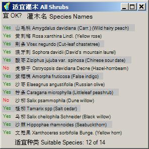
20 表 Table 4. 可用于多沙粗沙区植被重建的 38 种乔灌木品种 T = 乔木, S = 灌木 List of the 38 species used in the vegetation suitability analysis for the CSHC. In the column labelled Number the common species are identified with an asterisk. In the Growth form column, S and T represent shrub and tree, respectively. In the column labelled Fruit a Yes indicates a horticultural species whereas Yes ~ indicates a nonhorticultural species that produces edible fruit. 编号 Number 是否原生 Native 生长形态 Growth form 中文名 Chinese name 拉丁名 ( 英文名称 ) Latin name (Common name) 水果 Fruit 1 * Yes T 油松 Pinus tabulaeformis Carr. (Chinese pine) No 2 * Yes T 白桦 Betula Platyphylla Suk. (Asian white birch) No 3 * Yes S 山毛桃 Amygdalus davidiana (Carr.) C.de Vos. ex Henry. No (Wild hairy peach) 4 Yes S 黄刺梅 Rosa xanthina Lindl. (Yellow rose) No 5 * Yes T 辽东栎 Quercus liaotungensis Koidz. (Manchurian oak) No 6 * Yes T 白榆 Ulmus pumila (Siberian elm) No 7 * Yes T 小叶杨 Populus simonii Carr. (Chinese small leaf poplar) No 8 * Yes T 侧柏 Platycladus orientalis (L.) (Chinese arborvitae) No 9 Yes S 荆条 Vitex negundo Linn.var.heterophylla (Franch.) No Rehd (Cut-leaf chastetree) 10 Yes S 狼牙刺 Sophora davidii (David s mountain laurel) No 11 * No T 刺槐 Robinia pseudoacia (Black locust) No 12 * Yes T 旱柳 Salix matsudana (Corkscrew willow) No 13 Yes S 酸枣 Ziziphus jujuba var. spinosa (Chinese sour date) Yes~ 14 Yes T 山杨 Populus davidiana (Mountain poplar) No 15 * Yes S 虎榛子 Ostryopsis davidiana Decne (Hazel-hornbeam) No 16 * No S 紫穗槐 Amorpha fruticosa (False indigo) No 17 Yes S 沙枣 Elaeagnus angustifolia (Russian olive) Yes~ 18 * Yes S 柠条 Caragana microphylla (Littleleaf peashrub) No 19 * Yes S 沙柳 Salix psammophila (Dune willow) No 20 Yes S 柽柳 Tamarix spp (Salt cedar) No 21 Yes S 乌柳 Salix cheilophila Schneider (Black willow) No 22 * Yes T 臭椿 Ailanthus altissima (Tree of heaven) No 23 * Yes S 沙棘 Hippophae rhamnoides (Seabuckthorn) Yes~ 24 Yes T 青杨 Populus cathayana Rehd (Korean poplar) No 25 No T 新疆杨 Populus alba cv. ([Western] White poplar) No 26 * Yes T 桃 Prunus davidiana (Peach) Yes 27 * Yes T 杏 Prunus armeniana var.ansu (Apricot) Yes 28 Yes T 毛白杨 Populus tomentosa carr. (Chinese white poplar) No 29 * Yes T 河北杨 Populus hopeiensis (Hopei poplar) No 30 * Yes T 苹果 Malus domestica Borkh (Apple) Yes 31 * Yes T 梨 Pyrus bretschneideri (Pear) Yes 32 Yes T 桑 Morus alba L. (Mulberry) Yes 33 Yes T 核桃 Juglans regia (Walnut) Yes 34 Yes S 文冠果 Xanthoceras sorbifolia Bunge. (Yellow horn) No 35 * Yes T 杜梨 Pyrus betulaefolia (Birch-leaved pear) No 36 Yes T 楸树 Catalpa bungei C.A.Mey (Beijing Catalpa) Yes~ 37 * Yes T 枣 Ziziphus jujuba Mill (Chinese date) Yes 38 No T 箭杆杨 Populus nigra var.thevestina (Dode) Bean. (Lombardy poplar) No CSIRO Land and Water Page 11
21 4. 降水量图 :1980 年至 2000 年共 21 年的平均年降水量 采用 ANUSPLIN (Hutchinson 2004b) 逐月插值 (McVicar et al. 2005) 再平均 Precipitation dataset: ISWC obtained monthly precipitation data at 58 meteorological stations in and around the CSHC for the 21-year period from 1980 to 2000 inclusive; these data were then interpolated with ANUSPLIN Version 4.3 (Hutchinson 2004b) using a bi-variate thin plate spline with a square root transformation of the dependent variable prior to spline fitting to produce monthly precipitation surfaces (McVicar et al. 2005). The precipitation dataset provided in ReVegIH is the average annual data of 21 years from 1980 to 2000; the maximum and minimum values are 556 mm and 276 mm, respectively. 5. 数字高程模型 DEM: 由杨勤科等 (Yang et al. 2005b) 利用 ANUDEM (Hutchinson 2004a) 由等高线 水系和高程点生成 多沙粗沙区高程范围 312 米到 2760 米, 坡度可超过 30 度 (Yang et al. 2005a) 由 100 米 DEM 提取的坡度小于实地坡度, 在处理中需要转换 DEM dataset: the 100 m resolution DEM dataset was created using ANUDEM Version 5.1 (Hutchinson 2004a) from contours, rivers and spot height data (Yang et al. 2005b). The resulting DEM is hydrologically correct, in that the river network defined from it is connected without any spurious small parallel streams being introduced. The elevations for the CSHC range from 312 m to 2,760 m, and slopes can exceed 30 from horizontal in the 100 m resolution model (Yang et al. 2005a). Slopes derived from the DEM are smaller than the slopes measured on-the-ground due to smoothing during the mapping and digitisation processes. For GIS models making use of this DEM means that slope rules developed from field data will require modification. 6. 流域界限图 : 利用 SedNet (Wilkinson et al. 2004) 由前述 DEM 生成 共 42 个流域, 名称见表 Table 5 Catchment boundaries: these data were extracted from the DEM using SedNet (Wilkinson et al. 2004). The 42 catchments of the CSHC are listed in 表 Table 县界图 : 由中国科学院水利部水土保持研究所提供, 系 1980 年代的县界 包括 70 个县区的部分或全部, 见表 Table 6 County boundaries: this dataset was provided by ISWC. The data were provided at 1:500,000 scale. There are 70 counties wholly or partially located in the CSHC ( 表 Table 6). Both measured data (county area, landuse, land limits, percent woody cover and precipitation) and simulated outputs (ET, woody area, runoff, re-vegetation target levels and priority areas) provided in ReVegIH are only relevant to the part of the county within the CSHC boundary. CSIRO Land and Water Page 12
22 表 Table 5. 多沙粗沙区 42 个流域的名称和面积 Names and areas of 42 catchments in the CSHC. They are numbered consecutively from north to south, see Wen et al. (2005) specifically their Figure 2 for the locations of the catchments. 编号 Number 流域名称 Catchment name 流域名称 Catchment name 面积 Area (km 2 ) 1 Honghe River 红河 5,698 2 Lamawan 喇嘛湾 Longwanggou River 龙王沟 1,777 4 Huangfuchuan River 皇甫川 3,509 5 Yangjiachuan River 杨家川 1,114 6 Kuyehe River 窟野河 9,050 7 Pianguanhe River 偏关河 2,078 8 Qingshuichuan River 清水川 Hequ 河曲 Xianchuanhe River 县川河 1, Gushanchuan River 孤山川 1, Zhujiachuan River 朱家川 2, Baode 保德 Wudinghe River 无定河 31, Tuweihe River 秃尾河 3, Wujiazhuang 武家庄 1, Huashuta-Luzihe River 化树塔 - 芦子河 Lanyihe River 岚漪河 2, Weifenhe River 蔚汾河 1, Zhongzhuang 中庄 Jialuhe River 佳芦河 1, Yangjiapu-Zhaojiaping 杨家铺 - 赵家坪 2, Qiushuihe River 湫水河 1, Nuanqushan 暖渠山 Sanchuanhe River 三川河 4, Hedi-Mutouyu 河底 - 木头峪 1, Chengjiazhuang 程家庄 Jinjiazhuang 靳家庄 YanHe River 延河 7, Qingjianhe River 清涧河 4, Lijiashan-Yanchasi 李家山 - 眼岔寺 Quchanhe River 屈产河 1, Yonghe River 雍河 2, Xinshuihe River 昕水河 4, Anhe-Guandao 安河 - 关道 Fenchuanhe River 汾川河 1, Xigelou 西葛沟 Wencheng-Wangjiayao 文城 - 王家窑 Zhouchuan River 州川河 Shiwanghe River 仕望川 2, Ehe River 鄂河 1, Sili-Jiyizhen 寺里 - 集义镇 1,133 合计 Total 112,728 km 2 CSIRO Land and Water Page 13
23 表 Table 6. 多沙粗沙区 70 个县的名称和界内面积 Names and areas of 70 counties in the CSHC. The area of a county refers to the part of the county within the CSHC. They are numbered consecutively from north to south, see Figure 3 of Wen et al. (2005) for full details. 编号 Number 代码 County code 县名 County name 县名 Chinese name 区内面积 Area within CSHC (km 2 ) 区内面积比例 Area within CSHC (%) HeLinGeErXian 和林格尔县 1, YouYuXian 右玉县 2, LiangChengXian 凉城县 TuoKeTuoXian 托克托县 QingShuiHeXian 清水河县 2, ZhunGeErQi 准格尔旗 6, PingLuQu 平鲁区 1, ZuoYunXian 左云县 DaLaTeQi 达拉特旗 DongShengShi 东胜市 PianGuanXian 偏关县 1, FuGu 府谷县 3, ShenMuXian 神木县 7, ShuoChengQu 朔城区 HeQuXian 河曲县 1, ShenChiXian 神池县 1, WuZhaiXian 五寨县 1, BaoDeXian 保德县 1, WuShenQi 乌审旗 6, KeLanXian 岢岚县 1, YiJinHuoLuoQi 伊金霍洛旗 2, NingWuXian 宁武县 YuLinXian 榆林县 7, XingXian 兴县 3, ETuoKeQi 鄂托克旗 JingLeXian 静乐县 ETuoKeQianQi 鄂托克前旗 2, JiaXian 佳县 1, HengShanXian 横山县 4, LinXian 临县 3, FangShanXian 方山县 1, LanXian 岚县 LouFanXian 娄烦县 MiZhiXian 米脂县 1, JingBianXian 靖边县 4, ZiZhouXian 子州县 1, SuiDeXian 绥德县 1, LiShiXian 离石县 1, WuBuXian 吴堡县 LiuLinXian 柳林县 1, ZiChangXian 子长县 2, ZhongYangXian 中阳县 1, DingBianXian 定边县 WenShuiXian 文水县 QingJianXian 清涧县 1, WuQiXian 吴旗县 FenYangXian 汾阳县 CSIRO Land and Water Page 14
24 编号 Number 代码 County code 县名 County name 县名 Chinese name 区内面积 Area within CSHC (km 2 ) 区内面积比例 Area within CSHC (%) AnSaiXian 安塞县 2, ShiLouXian 石楼县 1, XiaoYiXian 孝义县 ZhiDanXian 志丹县 YanChuanXian 延川县 1, JiaoKouXian 交口县 YanAnShi 延安市 3, YongHeXian 永和县 1, XiXian 隰县 1, YanChangXian 延长县 2, PuXian 蒲县 1, DaNingXian 大宁县 HongDongXian 洪洞县 YiChuanXian 宜川县 2, JiXian 吉县 1, LinFenShi 临汾市 GanQuanXian 甘泉县 XiangNingXian 乡宁县 FuXian 富县 HuangLongXian 黄龙县 1, LuoChuanXian 洛川县 HeJinXian 河津县 HanChengShi 韩城市 合计 Total 112,728 km 系统流程 System flow chart 模型工具模拟流程如图 Figure 5 这有两个不同的方式 : 如果显示土地利用现状图, 则先选定一个流域, 或一个县区, 再使用滑动条来调节该流域的林地覆盖率 ; 如果显示植被恢复适宜区图, 则需要选择一个恢复等级, 再选择一个土地限制类别 (WUF 或者 WUFA), 也选择是否显示优先恢复区, 此时的林地覆盖率随这些选择而定 The eco-hydrological simulation process (or the basic way ReVegIH is run to assess the impact of simulated re-vegetation on runoff) is demonstrated in 图 Figure 5. After first selecting a catchment or county boundary, percent woody cover can be simulated to change in two ways: (1) adjusting percent woody cover using a slide bar; or (2) selecting an appropriate target level / priority area and land limit combination for which the percent woody cover is automatically pre-defined. The model then computes the output ET and runoff values. In this way, the user can simulate various management scenarios in order to determine the best option for the situation. The first option allows generic, catchment-level (or county-level) scenario modelling (the percentage of woody cover over the whole catchment or county is simulated the exact location is not known), whereas the second option is spatially explicit (using 100 m resolution data) when modelling ET and runoff. When the target level /priority area and land limit combinations are used with the suitability mapping of the 38 species listed in 表 Table 4 the full decision support capacity of ReVegIH is seen; we explain how users can do this in sections and CSIRO Land and Water Page 15
25 Method 1: Active dataset: Landuse / Land Cover Output resolution: Catchment / County level User action: Change "%Woody Cover" slide bar 方法 1: 显示图件 : 土地利用精度 : 流域 / 县区用户操作 : 移动林地覆盖率滑动条 Start System 程序运行 Select a Catchment/County 选择流域或县区 Method 2: Active dataset: Re-vegetation area Output resolution: 100 m User action: Select Target Level, Priority Area and Land limit 方法 2: 显示图件 : 植被恢复适宜区精度 :100 米用户操作 : 选择植被恢复等级 / 优先恢复区 / 土地限制类型的组合 Change % Woody Cover 调整林地覆盖率 Choose Target and Priority Settings 选择植被恢复等级 Choose Land Limit 选择土地限制类型 Calculate Model Automatically 模型自动运算 Output Results 结果输出 图 Figure 5. 模型工具模拟流程 The ReVegIH system flow chart for eco-hydrological assessment. CSIRO Land and Water Page 16
26 2. 软件介绍 Software Description 2.1. 系统设计思路 System design considerations 基本要求 Essential requirements Certain requirements were set for ReVegIH in the initial stages of its design: 中英文对照 Bi-lingual: to reflect the fact that it is an output of an international cooperative project, it must be a single version with both English and Chinese on its user interface, not two separate single language versions. Additionally, it should have one set of C# code with both languages present in the interface to help minimise code development overheads; 简单易用 Easy to use: given that the potential users are likely to have limited computer skills, ReVegIH needed to be a straightforward, user-friendly application; 独立运行 Standalone: it must not require other software packages to support its functionality, especially basic GIS functions; 单机运行 CD distribution: due to slow (or non-existent) internet access for many potential users, the application should be distributed on CDs and installed locally, rather than as a web-based application (this essential requirement was decided by consultation with key Chinese stakeholders in August 2003); 对机器要求低 Low hardware requirement: it must run on a relatively low-level computer (at least a Pentium III 600 CPU with at least 384 MB RAM and at least 300 MB of free hard disk space) 实现方法 Methodology of implementing requirements 考虑到用户的计算机软硬件和技能,ReVegIH 有下述特点 : 数据自动读入, 数据预先处理 不同精度地图和用户操作简化 To meet the requirements listed in section 2.1.1, taking into account potential users computing ability and facility, ReVegIH was designed with the following features: data autoload, data pre-processing, different data resolution, and minimal user input requirements. These are described in detail below. 数据自动读入 Data auto-load 所有数据自动读入, 减少用户操作, 避免用户选择图件可能引起的迷惑 All data required to work with ReVegIH are loaded automatically while the application starts up, this greatly reduces user activity and possible confusion with data selection. CSIRO Land and Water Page 17
27 Preloaded geographic data include: 1. landuse/land cover; 2. re-vegetation area; 3. vegetation suitability; 4. annual precipitation; 5. DEM; 6. catchment boundaries; and 7. county boundaries. The sources of these data are described in section 1.1. When one of the first two datasets is selected, users can perform land cover simulations. As introduced in section 1.2 this modelling can be performed either at a catchment-level or county-level (using the landuse/land cover dataset) or it can be more spatially distributed (using the 100 m resolution re-vegetation area dataset). The user input required to perform this modelling is provided in section 数据预先处理 Data pre-processing 大范围图像的逐像元运算极其费时, 故而部分静态数据已预先处理 One CSHC 100 m resolution dataset has 5310 x 4050 cells. The time spent on cell-by-cell calculation could be tremendous and intolerable for most users, so wherever possible, static data that have already been processed were packaged with the software. In this way the running speed is much faster. 不同精度地图 Different data resolution 为节省运行时间和计算机内存空间, 可能用于详细分析的图件使用 100 米分辨率, 其它主要用于演示的图件使用 500 米分辨率 To reduce ReVegIH s hardware requirements of RAM, CPU and hard disk space and to ensure that all required components to successfully run ReVegIH fit onto one CD, two spatial resolutions of data are used: (1) The landuse/land cover dataset, DEM and average annual precipitation dataset are provided at 500 m resolution, for the CSHC they each require roughly 4 MB of RAM. The datasets are provided mainly for context, so 500 m resolution was determined to be sufficient. (2) The re-vegetation area dataset and vegetation suitability dataset may attract cell-by-cell analysis, so finer resolution was necessary and these datasets are provided at 100 m resolution, which requires roughly 90 MB of RAM each. Using raster data with two resolutions means only 384 MB of RAM is required to run ReVegIH and only 300 MB of free disk space is required to successfully load the application, so user s computer specifications are greatly relaxed. This allows more users without highend PCs in the CSHC to successfully install and run ReVegIH. CSIRO Land and Water Page 18

28 简化用户操作 Minimum user operations 尽量简化用户操作 : 不需键入任何东西, 所有选项都列明, 点击即可 改变林地覆盖通过滑动条实现 Dataset selection and information can be accessed from a series of drop down menus, from live radio-buttons, or from the toolbar embedded in the user interface. The use of the radiobuttons and toolbar means that the user can circumvent use of the drop down menu system. Users do not have to manually type in any information as all choices are embedded within ReVegIH. Selecting the suite of radio buttons and the toolbar is performed by clicking the respective active area of the screen with the mouse. For re-vegetation scenario planning at the catchment-level (or county-level), a slide bar is provided so users can simulate hydrological changes that would occur as the percentage of woody cover in the selected region is simulated to change; this is achieved by a mouse drag of the percent woody cover slide bar. The simulation of the hydrological impact occurs instantaneously when the percent woody cover value changes 用户界面介绍 The ReVegIH graphical user interface (GUI) 可以将用户界面按功能分成 9 个区域 B C A D E F G I H 图 Figure 6. ReVegIH 用户界面, 可按蓝线划成 9 个部分, 由红色大写字母注明 The ReVegIH graphical user interface (GUI) is shown. Blue rectangles define the 9 segments, each denoted by a large red letter. Note, when running ReVegIH the blue rectangles and red letters are not shown; they are used here to explain the GUI. CSIRO Land and Water Page 19
29 The ReVegIH GUI can be segmented into 9 parts based on their functions ( 图 Figure 6): A: 菜单区 Menus B: 地图显示区 Display area C: 工具选择 Toolbar D: 模型结果显示区 Modelling output area E: 区域划分方式 Mapped by area F: 显示地图 Show dataset area G: 植被恢复适宜区 Target level settings H: 鼠标所在区域的相关信息 Information of mouse over region I: 模式显示 Mode status bar The 9 parts of the application are explained in detail in the following sections 菜单区 Menus (A) 菜单区 ( 图 Figure 6 红 A) 四个菜单的内容如表格表 Table 7 表 Table 8 表 Table 9 和表 Table 10 所示 The Menu area (red A in 图 Figure 6) contains all the commands to work with ReVegIH. There are four menus on the menu bar: Show Dataset, View Info, Tools, and Help. Items in each menu are explained in 表 Table 7, 表 Table 8, 表 Table 9 and 表 Table 10 respectively. Please note Info is a working abbreviation for Information that is used in the following. 显示地图菜单 Menu 1: Show Dataset 从 5 个专题地图中选择一个来显示, 从 2 个界限图中选一个分界方式 ( 图 Figure 6 红 B) The Show Dataset menu is used to select the dataset to display in the display area (red B in 图 Figure 6). The first five datasets are raster data. Only one raster dataset can be displayed at a time. The last two are vector datasets. Only one vector dataset can be displayed on top of a raster dataset at any given time. 表 Table 7. 显示地图菜单 Items in Show Dataset menu. The dashed line separates the raster datasets, vector datasets and the option to exit. 命令 Item 土地利用图 Landuse/Land Cover 植被恢复适宜区 Re-Vegetation Area 植被适宜图 Vegetation Suitability 数字高程模型 DEM 降水量图 Annual Precipitation 流域界线图 Catchment Boundaries 县区界线图 County Boundaries 退出 Exit 作用 Purpose 显示土地利用图 Display landuse/land cover dataset 显示植被恢复适宜区 Display re-vegetation area dataset 显示植被适宜图 Display vegetation suitability dataset 显示数字高程模型 Display DEM dataset 显示降水量图 Display annual precipitation dataset 显示流域界线图 Display catchment boundaries 显示县区界线图 Display county boundaries 退出 Close ReVegIH CSIRO Land and Water Page 20
30 Raster datasets can also be selected from within the Show Raster Dataset area (red F in 图 Figure 6); vector datasets can also be selected from within the Mapped By area (red E in 图 Figure 6). By default, the catchment boundaries are overlayed on the landuse/land cover dataset when the application first starts. If the user does not select a specific catchment or county the modelling results are applicable to the entire CSHC. 显示信息菜单 Menu 2: View Info 选择想要查看的信息 5 种信息对应 5 种地图, 但植被适宜性信息包含 7 组 查看信息将自动打开信息显示选项, 见 节 This menu is used to select an information type to view about the displayed raster map. There are five items on it, related to five raster datasets (listed on menu 1, Show Dataset). Of them, Vegetation Suitability contains 7 sub-items so users have the choice to view information relevant to a specific vegetation group. 表 Table 8. 显示信息菜单 Items in View Info menu. 命令 Item 土地利用类型 Landuse/Land Cover 植被恢复适宜区 Re-Vegetation Area 适宜植被 Vegetation Suitability 全部种类 All Species 全部乔木 All Trees 全部灌木 All Shrubs 常见种类 Common Species 常见乔木 Common Trees 常见灌木 Common Shrubs 全部果树 All Fruit Trees 高程 DEM 降水量 Precipitation 作用 Purpose 显示土地利用类型 View landuse/land cover class name 显示植被恢复适宜区信息 View re-vegetation dataset information 显示适宜植被 View vegetation suitability information 显示全部种类 View suitability of all 38 species 显示全部乔木 View suitability of all 24 trees 显示全部灌木 View suitability of all 14 shrubs 显示常见种类 View suitability of 22 common species 显示常见乔木 View suitability of 16 common trees 显示常见灌木 View suitability of 6 common shrubs 显示全部果树 View suitability of 11 fruit trees 显示高程 View elevation in metres 显示降水量 View average annual precipitation in mm Selecting any item on this menu also turns the Show Info (explained in section 3.2.2) option on. Items in this menu are accessible via a popup menu, see section for details. 工具菜单 Menu 3: Tools 选择一个地图工具 这里的工具也都出现在工具栏 ( 图 Figure 6 的红 C) This menu contains a collection of tools for working with datasets and dataset information. All items here are accessible through the Toolbar (red C in 图 Figure 6); please see section regarding the toolbar. CSIRO Land and Water Page 21
31 表 Table 9. 工具菜单 Items in Tools menu. The dashed line separates the functionality provided by this part of ReVegIH. 命令 Item 放大所选区域 Zoom Selected Region 显示整个地区 Zoom to CSHC 放大模式 Zoom In 缩小模式 Zoom Out 漫游模式 Pan 回复选择模式 Back to Pointer 寻找流域 Catchment Search / County Search 显示地图信息 Show Map Information 作用 Purpose 将所选区域全部显示在地图显示区 Display the selected region on the display area 显示整个地区 Scale display to whole CSHC 放大地图 Enlarge map display 缩小地图 Reduce map display 漫游地图 Re-centre and pan map 回复选择模式 ( 正常模式 )Change back to pointer (normal mode) 寻找某个流域或区县 Search for a catchment (or county) from a dropdown list 打开 / 关闭信息 Turn on/off Show-Info option 帮助菜单 Menu 4: Help 得到帮助信息 This menu allows the user to access the ReVegIH version information and Help file. 表 Table 10. 帮助菜单 Items in Help menu. 命令 Item 使用说明 How to use... 文献 References 关于 About 作用 Purpose 打开使用说明 Open ReVegIH help file 课题有关的论文与报告 Link to relevant journal papers and technical reports 版权版本信息 Open copyright window 地图显示区 Display area (B) 图 Figure 6 红 B 用于地图显示 每次都只能有一个分区地图 ( 县界或流域界图 ) 和一个专题图 用户可以 : 选择一个流域或县区用于模拟 ; 选择一种信息来查看 ; 或 缩放地图 This area (red B in 图 Figure 6) is reserved for map display. At any time, there is one vector dataset on top of a raster dataset. The datasets displayed are selectable and zoomable. Within this area, you can Select a catchment or county for simulation; Select which dataset information type to view; and Zoom and pan the display 工具选择 Toolbar (C) 这里 ( 图 Figure 6 红 C) 选择不同的地图工具和其它工具, 包括显示多沙粗沙区 显示所选区域 放大 缩小 漫游 正常选择 查找和显示信息 这里的工具也都出现在工具菜单 用户可以 : CSIRO Land and Water Page 22
32 选择一个工具, 继而 改变地图操作模式 The toolbar (red C in 图 Figure 6) allows the user to choose various options for map display and information display. Available tools (from top to bottom) are ZoomToRegion, ZoomToCSHC, ZoomIn, ZoomOut, Pan, Pointer, Search and ShowInfo. This part is also accessible through menu 工具 Tools. See for available tools and their purposes. You can: Choose a tool; and consequently Change the mode 模型结果显示区 Modelling output area (D) 该区 ( 图 Figure 6 红 D) 显示模型运算结果, 也显示当前土地利用方式下的径流和蒸散发值 如果显示的是土地利用图, 则滑动条可以移动, 改变林地覆盖率进行模拟 如果显示的是植被恢复适宜区图, 用户不能移动滑动条 此时显示的是该种恢复组合下的林地覆盖率的模拟结果 如图 Figure 7 所示, 共有 4 个文字框, 左上方兰底黑字的是当前利用状况下的径流量, 其下的 9.4% 是径流占降雨的比例 ; 右上方兰底黑字的是模拟利用状况下的径流量, 其下的 8.4% 是此时径流占降雨的比例 ; 两个百分数中间括号里的 -9.8% 是径流的相对变化 ; 左下方红底黑字的是当前利用状况下的蒸发蒸腾量, 其下的 90.6% 是蒸发蒸腾占降雨的比例 ; 右下方红底黑字的是模拟利用状况下的蒸发蒸腾量, 其下的 91.6% 是此时蒸发蒸腾占降雨的比例 ; 两个百分数中间括号里的 +1% 是蒸发蒸腾的相对变化 用户可以 : 改变滑动条数值以模拟林地改变对径流 / 蒸发蒸腾的影响 Results of rainfall-runoff modelling are displayed in this area (red D in 图 Figure 6); with 图 Figure 7 below providing more details. This area is active only when either the landuse dataset or re-vegetation area dataset is shown. The Runoff and ET under the current landuse scheme for the selected region (either a catchment or county shown with a yellow boundary on area B in 图 Figure 6) are shown on the left hand side, while the Runoff and ET under the simulated landuse scheme are shown on the right hand side. The bolded percentages for both the current and simulated woody conditions represent the percentage of average annual precipitation that is partitioned into ET and runoff, whereas the non-bold percentages in parenthesis (reported in the middle of the current and simulated woody conditions) are the simulated changes relative to current conditions for ET and runoff respectively. That is, with an increase in percentage woody cover, the value in brackets reveals the decrease in runoff relative to current conditions this is likely to be of most use for water resource managers. Note that only one catchment or county can be selected at any one time, if a sub-region is not selected then results are applicable to the entire CSHC. CSIRO Land and Water Page 23

33 There are four textboxes displaying runoff and ET for current and simulated landuse conditions respectively. The name of the selected region is shown on the bottom-left corner; if no catchment or county is selected then the whole CSHC is modelled by default. 图 Figure 7. 模型结果显示区 Illustration of modelling output area, either a catchment or a county in the CSHC. The units Ml in the figure stand for Megalitres (10 6 litres). The bolded values are the percentage of annual precipitation partitioned into either runoff or ET, whereas the non-bolded values reported in parenthesis (in the middle of the precipitation partitioning) are the percentage change for the simulated conditions relative to the current conditions and are calculated for runoff and ET independently. When the landuse dataset is selected (red F in 图 Figure 6), the % Woody Cover scroll bar is active and adjustable allowing the percent woody cover of the selected region to be simulated to increase (or decrease) with the estimates of Runoff and ET changing accordingly. When the re-vegetation areas dataset is selected, the display shows the simulated output for the selected target level /priority area and land limit combination, the scroll bar indicates the percentage woody cover under this re-vegetation combination and is not manually adjustable. You can: Adjust the % Woody Cover scroll bar to simulate the corresponding changes of the partitioning of annual average precipitation into annual average runoff and annual average ET for the selected catchment (or county) 区域划分方式 Mapped by (E) 从这里 ( 图 Figure 6 红 E) 用户可以选择将多沙粗沙区按流域划分 分析, 还是按县界划分 分析 效果如图 Figure 8 所示 用户可以 : 选择按流域还是县区进行模拟 This area (red E in 图 Figure 6) provides the option to select and display a vector dataset, either the CSHC catchment boundary or county boundary on top of a raster dataset. If the catchment map is selected, modelling will be performed for a catchment. Likewise, if the county map is selected, modelling will be performed for a county. 图 Figure 8 illustrates the different views of these two selections. CSIRO Land and Water Page 24

34 (a) (b) 图 Figure 8. 左图按流域划分, 右图按县区界限划分 Effects of Mapped by selection are shown. CSHC is mapped by (a) catchments and (b) counties. The Landuse/Land Cover raster dataset is in the background. The landuse/land cover classes can be queried by requesting information from this dataset as outlined in section This selecting function is also accessible through the menu Show Dataset. You can: Choose the way to segment the CSHC either by county, or catchment 显示地图 Show dataset (F) 共有 5 个专题地图供选择 用户可以从这里 ( 图 Figure 6 红 F) 选择任意一个专题地图来显示 Choose a raster dataset to display, (red F in 图 Figure 6). As illustrated previously there are five datasets to choose from. They are: Landuse/Land Cover; Re-vegetation Area; Vegetation Suitability; DEM; and Precipitation. You can: Choose a dataset to display. As discussed previously (section 1.1) to minimise computer system requirements the landuse, DEM and precipitation rasters are provided at 500 m resolution, with 100 m resolution data being provided for the landuse/land cover and re-vegetation area datasets. The ability to simulate the impact that re-vegetation will have on regional hydrology is only available when the landuse/land cover dataset or the re-vegetation area dataset is selected. The other raster datasets provide environmental context. As introduced previously (section 1.2) there are two methods of performing the simulation modelling: (1) at the catchment (or CSIRO Land and Water Page 25
35 county) level using the landuse/land cover dataset; and (2) spatially distributed at 100 m resolution using the re-vegetation area dataset. The two methods of allowable user interaction to simulate landuse change are discussed fully in section below 植被恢复适宜区 Target level settings (G) 当显示植被恢复适宜区地图时, 该部分 ( 图 Figure 6 红 G) 激活, 供用户选择 基本概念见 1.1 相关部分 每个流域和县区不同恢复水平的面积和优先恢复区面积见植被适宜性技术报告 (Wen et al. 2005) 的附录部分 延河流域作为一个代表, 如图 Figure 9 所示 选择优先恢复区后, 优先恢复区以黑色显示在适宜恢复区上面, 模型运算也只针对优先恢复区 你可以 选择植被恢复等级 ; 选择土地限制因素类型 ( 无法造林或已经造林的地区 ); 以及 选择是否显示植被优先恢复地区 The Target level setting area (red G in 图 Figure 6) is active when the re-vegetation area dataset is selected (red F in 图 Figure 6). See 1.1 for more explanations. The re-vegetation target level is set to one of three levels corresponding to three different vegetation groups: 1 for trees, 2 for shrubs, 3 for grasses (left tab in G). When the Show Priority Area option is ticked, the re-vegetation priority areas for the selected target level will be shown in black on top of the pre-selected target area, see 图 Figure 4 for the spatial relationship. Once ticked, the hydrological simulations are then only driven by the priority area and land limit combination for the selected region. For each target level / priority area, some areas should not be included in any sensible revegetation scheme, as they are either unsuitable (water, urban), or already woody perennials; this land limit is named WUF (water, urban, and forest). With the WUF land limit selected the area that can potentially be re-vegetated is comprised of the Target area minus the WUF land limit. Managers of some regions may not want to re-vegetate highly productive agricultural lands. In these cases, the land limit becomes WUFA (water, urban, forest and agriculture). With the WUFA land limit selected the area that can potentially be revegetated is comprised of the Target area minus the WUFA land limit. As stated previously, for WUF and WUFA the forest class represents the perennial woody vegetation that is comprised of the forest, sparse forest and shrubland as introduced in the Landuse/Land Cover dataset. We maintain calling it forest to capture the focus of the major historical revegetation effort in the area. You can: Choose a target level; Choose a land limit type (areas not included in re-vegetation scheme); and Choose to show the re-vegetation priority areas. CSIRO Land and Water Page 26
36 The areas for three different target levels (and priority areas) for each catchment and county have been pre-processed, for details see the appendices of Wen et al. (2005). An example summary for Yanhe River is given in 图 Figure 9. The pre-processed areas have been used in the model so that for every target level / priority area and land limit combination the hydrological impact of re-vegetating the pre-defined area is calculated. This has been performed for each catchment and county in the CSHC. SSG: 极陡坡 Steep slope and gully; P1: 一级适宜恢复区的优先区 Priority area for target level 1 (trees); P2: 二级适宜恢复区的优先区 Priority area for target level 2 (shrubs); P3: 三级适宜恢复区的优先区 Priority area for level 3 (grasses); T1: 一级适宜恢复区 Target level 1; T2: 二级适宜恢复区 Target level 2; T3: 三级适宜恢复区 Target level 3. 图 Figure 9. 延河流域极陡坡 适宜恢复区和优先恢复区面积比较 Comparison of SSG, revegetation priority and target areas for YanHe catchment. For P1 to T3 (inclusive) the lighter bar on the left of the pair represents the WUF land limit, while the darker bar on the right of the pair represents the WUFA land limit. This graph is not dynamically generated by ReVegIH, it summarises the pre-processing, similar summary graphs are provided in the Appendices of Wen et al. (2005) for all 42 catchments and for the 36 counties that have over 90% of their area within the CSHC 鼠标所在区域的相关信息 Information of mouse over region (H) 当鼠标在地图 ( 图 Figure 6 红 A) 移动时, 它所在流域 ( 县 ) 的名称 位置 ( 经纬度 ) 面积 林地覆盖率和年降雨量值都在这里 ( 图 Figure 6 红 H) 显示出来 用户可以 : 察看区域数据信息 The information shown in this area (red H in 图 Figure 6) changes as the user moves the mouse around. The items shown include (from left to right) region name in Chinese and in English, longitude and latitude, area (km 2 ), current woody cover (%), and average annual precipitation (mm). The area statistic is the size of the region that is located in the CSHC, the catchments are all located in the CSHC yet the county area in the CSHC may be smaller than the entire county due to the hydrologic determination of the study site boundary. Please note information can be gained for an area even though it is not the selected region. You can: View data attribute information. CSIRO Land and Water Page 27
37 模式显示 Mode status bar (I) 当前模式在这里显示 ( 图 Figure 6 红 I) 模式共有四种 : 放大 缩小 漫游和正常, 可以从鼠标形式 ( 位于图 Figure 6 红色 B 区域时 ) 看出来, 也可以从工具栏看出 ( 压下去的纽扣 ) 只有正常状态下才能选择一个流域 ( 县 ) 进行模拟 正常模式 : 选择一个流域或县区 ; 单击右键显示弹出菜单 ; 放大模式 : 放大地图 ; 缩小模式 : 缩小地图 ; 漫游模式 : 地图漫游 用户可以 : 查看当前模式 The mode status bar (red I in 图 Figure 6) reports the four available modes ZoomIn, ZoomOut, Pan and Pointer (the default or normal condition) when performing map and information manipulation tasks. They are identifiable via the cursor, which has a different cursor icon over the map display area (red B in 图 Figure 6), and also via the toolbar where a pushed button indicates the current mode. Users can select a mode via the Toolbar or menu 工具 Tools, which is explained in section and Normal mode: select a region to simulate; show popup menu when Show Info is turned on; ZoomIn: Zoom in displayed dataset; ZoomOut: Zoom out displayed dataset; Pan: Pan/re-centre displayed dataset; You can: View current mode 系统要求 System requirements 该软件为微软视窗 XP 开发, 中文和英文系统都行 也可能会在视窗 2000 上运行, 但尚未全面测试 因为是在.NET 下开发的所以你的计算机需要预先安装有.NET Framework 参看常见问题一节 硬盘要求 :300 兆 处理器 : 奔腾 以上 内存 : 至少 384 兆, 最好超过 1 G The ReVegIH application is designed for Windows XP; it has been tested to work satisfactorily with both the English or Chinese versions of this operating system. For Windows 2000 ReVegIH has only been tested with the Chinese version; and it works well. No other programs are required to run ReVegIH. However, you must have the Microsoft.Net Framework preinstalled. The framework is distributed for free on the ReVegIH CD; see Trouble shooting in section 4.1 for more details. CSIRO Land and Water Page 28
38 The minimum system requirements to successfully load and run ReVegIH are: Hard disk: 300 MB Processor: Pentium III 600 and above Memory required by the application: minimum 384 MB, preferably 1 GB. CSIRO Land and Water Page 29
39 3. 使用 Using ReVegIH 请参阅封二页有关使用 ReVegIH 的重要声明 Please see the important disclaimer regarding the use of ReVegIH on the verso title page of this guide 安装 卸载与运行 Installing, uninstalling and running 安装 Installing ReVegIH 插入 CD, 如果安装程序不自动运行, 就找到 ReVegIH_Setup.exe, 双击, 开始安装 按部就班, 接受默认设置就行 To install ReVegIH from the distribution CD-ROM, insert the ReVegIH CD into your CD drive. The autorun capability of Windows will start the ReVegIH setup program. If it does not, find and double click ReVegIH_Setup.exe on the CD to start the setup manually. The installation wizard will lead you through the entire installation. Unless you really want to override the defaults, you can just press OK (or Yes, or Next, as appropriate) to accept the installation default settings. We strongly recommend that users accept the default installation settings 启动 Starting ReVegIH 选择任意一个启动方法 : 1. 双击 ReVegIH 图标 ; 或者 2. 开始 程序 ReVegIH You can start ReVegIH through either: 1. double clicking on the ReVegIH icon on your desk top; or 2. through the menu, Start Programs ReVegIH 退出 Exiting ReVegIH 选择菜单的退出命令, 或点击程序的退出按钮, 都可以退出程序 You can exit ReVegIH through any of the following methods: 1. click the cross button ( ) on the top-right corner of the ReVegIH window; 2. click the Exit button ( ) on the bottom-right corner of the ReVegIH window; or 3. the menu 显示地图 Show Dataset 退出 Exit. CSIRO Land and Water Page 30
40 卸载 Uninstalling ReVegIH 可以从视窗控制面板的删 / 加软件窗口中卸载, 也可以用 ReVegIH 自带的卸载程序卸载它 There are two ways to uninstall ReVegIH from your computer should you wish to do so: 1. Control Panel: Control Panel Add/Remove Programs ReVegIH; or 2. Start Menu: Start menu Programs ReVegIH Uninstall ReVegIH.exe. The Uninstall ReVegIH procedure will delete files in Program File\ReVegIH folder, remove the ReVegIH icons, ReVegIH desktop shortcut and Start menu entries 使用 Working with ReVegIH 显示地图 Displaying datasets 有两个方法选择一个地图来显示 : 方法 1: 从菜单区显示地图 Show Dataset 选择 ; 方法 2: 从显示地图 Show Dataset 区选择 第一次显示植被恢复适宜区地图和植被适宜性地图时, 费时会很长 There are two ways a user can choose a dataset to display: Method 1: from the menu area (red A in 图 Figure 6): 1. select 显示地图 Show Dataset from the main menu; 2. select the desired dataset name. Method 2: from Show Dataset area (red F in 图 Figure 6): click the button next to the desired dataset name. Given the 100 m resolution of the re-vegetation area dataset and vegetation suitability dataset (compared to the 500 m resolution of the other raster datasets section 1.1), it takes a longer time to display these for the first time in each session 打开 / 关闭显示信息选项 Toggle show information option 显示信息选项使得用户可以选择察看或不察看地图信息 如果打开它, 鼠标所在像元的信息就会在屏幕显示 方法 1: 从菜单区工具 Tools 选择显示地图信息 Show Map Information; 方法 2: 从工具栏点击 ViewInfo Tool ( ).; 再次选择或点击上述选项则会关闭信息窗口 The Show Info option provides users with the flexibility to view raster map information or to not view raster map information. When the option is on, a window showing information of the cell at the cursor point is displayed and the information updates as the user moves the mouse over the map display area. For example, an expected common use of ReVegIH is CSIRO Land and Water Page 31


41 when users display the re-vegetation dataset as a back drop and query the vegetation suitability database this is illustrated in 图 Figure 10. Given that both the re-vegetation dataset and vegetation suitability dataset have 100 m spatial resolution and with the precision of the latitude and longitude data shown in the GUI (see red H in 图 Figure 6) users can use ReVegIH to determine where re-vegetation activities can be undertaken. With the aid of a GPS, users can find the same location in the landscape. We recommend that some detailed site assessment be undertaken prior to performing any re-planting as ReVegIH is a regional scale decision support tool, and local factors (near and below the resolution of the data used in the application) may be critical in determining success (or failure) of revegetation schemes. 图 Figure 10. 显示植被适宜区图时, 逐像元检查其适宜的树种 An example of spatially exploring the 100 m resolution re-vegetation dataset (showing the target level / priority area and land limit combination) while dynamically gaining vegetation suitability information for all 24 tree species at 100 m resolution for each grid cell of the re-vegetation dataset. To turn the Show Info option on and display an information window: Method 1: from the menu area (red A in 图 Figure 6): 1. select 工具 Tools to open the menu; 2. select 显示地图信息 Show Map Information. Method 2: from Toolbar (red C in 图 Figure 6): click on ViewInfo Tool ( ). Method 3: from the menu area (red A in 图 Figure 6): 1. select 显示信息 View Info to open the menu. 2. click on an item. CSIRO Land and Water Page 32
: click on Showinfo Tool ( ). Generally, a user can turn off the Info window only when it is on, and vice versa.")
42 To turn the Show Info option off and hide the information window: Method 1: from menu area (red A in 图 Figure 6): 1. select 工具 Tools to open the menu; 2. select 关闭地图信息 Don t Show Map Info. Method 2: from Toolbar (red C in 图 Figure 6): click on Showinfo Tool ( ). Generally, a user can turn off the Info window only when it is on, and vice versa. But selecting an item from menu 显示信息 View Info (method 3 above) will always turn the Show Info option on. If a dataset has not been loaded yet, a request to show its information will do so 显示信息 Viewing information 当信息窗口打开后, 你可以选择一种地图信息来显示 不必是正在显示的地图的信息, 比如说, 显示土地利用图, 察看降雨量值 例如表 Table 11 所示 方法 1: 从菜单区显示信息 View Info 选择 ; 方法 2: 鼠标放在地图上面, 点击右键, 显示弹跳菜单, 选择 The information for a given cell of a given dataset can be shown when the Show Info option is on. (See Toggle show information option above). To view map information: Method 1: from menu area (red A in 图 Figure 6): 1. select 显示信息 View Info to open the menu; 2. click on an item. Method 2: from popup menu when Show Info is on: 1. point mouse cursor somewhere over the display area (red B in 图 Figure 6); 2. right click mouse button shows the following menu. A user must choose normal mode (pointer) to activate the popup menu. Landuse/Land Cover, Re-vegetation Area, DEM and Precipitation information will be shown at the mouse pointer, while vegetation suitability information is shown on a separate window. The information shown does not have to come from the displayed dataset. That is, a user CSIRO Land and Water Page 33


43 can display one dataset and view the information for one of the other datasets. This is illustrated in 表 Table 11, with the anticipated common use of ReVegIH illustrated in 图 Figure 10. 表 Table 11. 显示土地利用图时, 察看不同的地图信息 Examples of viewing different map information are illustrated. The landuse dataset is displayed throughout, and information for landuse, re-vegetation area, DEM, and precipitation are viewed consecutively. The information provided changes as a user moves the mouse location. For vegetation suitability all 7 predefined groupings are shown from (a) to (g). 信息选择 Information viewed option 屏幕抓图 Screenshot 土地利用图 Landuse/Land Cover: 显示土地利用类型 Landuse/Land Cover class is displayed 植被恢复适宜区图 Re-vegetation area: 区分非造林区, 一级 二级和三级恢复区和不宜植树区 Target areas for different levels, priority areas, and land limits and non re-vegetation areas are identified DEM: 显示海拔 Elevation is shown (metres) 降水量图 Precipitation: 显示多年平均降水量 Average annual precipitation is shown (mm). 植被适宜性信息在另外一个窗口列出, 分成 7 种, 用户可任选其一 适宜的用绿色 Yes 标明, 不适宜的用红色 No 标明 Vegetation suitability information is listed in a separate window. Users can choose 1 of the 7 pre-defined groups. A Green Yes listed in the left column means the species listed in the right column is suitable for the cell of interest. Alternately, a red No means the cell is unsuitable for the given species. The 7 pre-defined lists are: (a) All Fruit Trees (11); (b) All Species (38); (c) All Trees (24); (d) All Shrubs (14); (e) Common Species (22); (f) Common Trees (16); and (g) Common Shrubs (6). The numbers in brackets represent the number of species in each group. (a) CSIRO Land and Water Page 34
 CSIRO")

44 (c) (b) (d) CSIRO Land and Water Page 35


: 1. click on the Search Tool ( ).")
45 (f) (e) (g) 选择区域 Selecting and unselecting a county/catchment 可以在正常状态点击选择一个流域或一个县, 也可以从流域目录和区县目录中查找 : 方法 1: 从菜单区工具 Tools 点击寻找流域 Catchment Search 激活目录 ; 线 方法 2: 从工具栏点击 Search Tool ( ) 激活目录 选择一个县区的方法跟选择一个流域的方法相同, 被选的流域或区县边界变成黄色粗压住控制键, 同时点击所选区域就可以不选它, 这时整个多沙粗沙区就被选上 To select a catchment, use either: Method 1: manually select by pointing and clicking the mouse in the area defined by the red B in 图 Figure 6: 1. In normal mode, click on a catchment. Method 2: make selection from a list via the Toolbar (red C in 图 Figure 6): 1. click on the Search Tool ( ). A catchment list will show up; 2. scroll and choose one from the list. Method 3: select from a list via menus (red A in 图 Figure 6): CSIRO Land and Water Page 36

.")
46 1. select 工具 Tools to open the menu; 2. click 寻找流域 Catchment Search. Once a catchment is selected, its boundary changes to yellow, and its name appears in red text in the bottom left corner of area D in 图 Figure 6. Users can then use the ZoomToRegion Tool ( ) to zoom to that region. If a user wants to search for a county, then it must be mapped by counties (red E in 图 Figure 6) first. The methods to select a county are the same as for a catchment except the dropdown menu list will be a county list rather than a catchment list ( 图 Figure 11). 区域划分方式 Mapped by 显示的目录 Name list 图 Figure 11. 查寻流域和县区时的目录随流域划分方式而变 The catchment list or county list displays in accordance to the Mapped By option. Both are sorted alphabetically by the PinYin version of the Chinese script. To unselect the selected catchment (or county): Method: In the normal mode click on the currently selected region while holding down the Ctrl key. The yellow boundary around the selected region will disappear and the entire CSHC will be selected. Switching between Mapped by catchments to Mapped by counties (red E in 图 Figure 6) will set the selected region back to the whole CSHC 地图缩放 Zooming and panning maps 地图缩放共有 5 个工具, 名称和使用方法见下表 显示所选流域和显示整个多沙粗沙区两个工具, 点击一次就可, 都不改变当前的模式 如果要放大 : 可以直接点击地图某处来放大, 该点是新显示图的中心点 ; 也可以画一个框设定显示区域 如果要缩小, 可以直接点击地图某处, 该点也是新显示图的中心点 CSIRO Land and Water Page 37
47 如果要漫游 : 可以点击, 也可以抓着走 There are 5 zooming/panning tools available: ZoomToRegion, WholeCSHC, ZoomIn, ZoomOut and Pan. Each similarly has two methods of access ( 表 Table 12 below). 表 Table 12. 选择地图缩放的方法 Methods to access map zooming/panning tools. 工具 Tools 所选区域 ZoomToRegion 显示整个地区 ZoomToCSHC 放大 ZoomIn 缩小 ZoomOut 漫游 Pan 方法 1: 从工具栏 Method 1: click Toolbar (red C in 图 Figure 6) 点击 Click on 点击 Click on 点击 Click on 点击 Click on 点击 Click on 方法 2: 从菜单工具 Tools 进 Method 2: select menu 工具 Tools (red A in 图 Figure 6) 选择 Select 放大所选区域 Zoom Selected Region 选择 Select 显示整个地区 Zoom to CSHC 选择 Select 放大模式 Zoom In 选择 Select 缩小模式 Zoom Out 选择 Select 漫游模式 Pan To zoom to the selected region (a catchment or a county with yellow boundary): Accessing the ZoomToRegion tool will zoom to the selected region. If no region is selected, this tool does nothing. To show whole CSHC: Accessing the Zoom to CSHC tool will zoom to the CSHC extent. To zoom in: 1. access the ZoomIn tool; 2. click on the area you are interested in, or draw a box (left mouse click, hold and move) around your interested area. To zoom out: 1. access the ZoomOut tool; 2. click on the area you are interested in, or draw a box to show your interested zoom out ratio. To pan a map: 1. access the Pan tool; 2. click on the area you want to be the centre of the display, or click and drag in order to reposition the display 模式转换 Changing modes 4 种模式见下表, 主要用于控制地图缩放 当前的模式可以从用户界面左下角 ( 图 Figure 6 上红色字母 I 所指示的地方 ) 看出, 也可以从工具栏看出 ( 压下去的纽扣 ) 模式转换方式如下表, 在工具栏上顾名思义, 点击图标即可 CSIRO Land and Water Page 38
48 The mode displayed on the mode status bar (red I in 图 Figure 6) can be changed via the Toolbar (red C in 图 Figure 6), or menu 工具 Tools (red A in 图 Figure 6), please see 表 Table 13. 表 Table 13. 转换模式的方法 Methods to change modes. 模式 Mode 正常 Normal mode 放大 Zoom in mode 缩小 Zoom out mode 漫游 Pan 方法 1: 从工具栏 Method 1: Click Toolbar 点击 Click on 点击 Click on 点击 Click on 点击 Click on 方法 2: 从菜单工具 Tools 进 Method 2: Select menu 工具 Tools 选择 Select Back to Pointer 选择 Select 放大模式 Zoom In 选择 Select 缩小模式 Zoom Out 选择 Select 漫游模式 Pan 土地利用变化模拟 Simulating landuse change 如果显示土地利用图, 则可以移动滑动条以改变林地覆盖率, 进行模拟 植被恢复适宜区是适宜人工植树种草的部位, 由植被恢复程度和土地限制条件两方面组合而成 ( 图 Figure 12) 如果显示的是植被恢复适宜区图, 用户不能移动滑动条 此时显示的是该种恢复组合下的林地覆盖率的模拟结果 如果选择优先恢复区被打勾, 则意味着只恢复优先恢复区的植被 安塞县不同的土地限制与优先恢复区的组合产生的效果见图 Figure 13 因为不能将水体 城镇和极陡沟 坡变成森林, 所以每个县和流域都有一个最高林地覆盖率 张橹等开发的模型中只有林地面积的改变才会对产流带来影响, 所以当用户选择恢复水平为灌木和恢复水平为草地时, 模拟的蒸散发量和径流量不变, 但地图显示的适宜恢复区面积则发生变化 见图 Figure 14 所示 进行模拟的办法 : 如果显示的是土地利用图 改变滑动条数值以模拟林地改变对径流 / 蒸发蒸腾的影响 如果显示的是植被恢复适宜性图 1. 选择植被恢复等级 ; 2. 选择土地限制因素类型 ( 无法造林或已经造林的地区 ); 3. 选择是否显示植被优先恢复地区 When the landuse/land cover dataset is displayed, the % Woody cover scroll bar is active for adjusting the percent woody perennials of the selected region; the modelled Runoff and ET data will change accordingly. The steps are: 1. select a region; and then 2. scroll the bar. It is assumed we can not plant vegetation on water bodies, urban areas and very steep slopes and gullies. Since these landuse classes take up a certain amount of area in every CSIRO Land and Water Page 39
 level and only the percentage of the selected area simulated to be covered with woody vegetation is used in the calculations.")
49 region, there is a maximum percentage for each region that can not be exceeded (which in most cases would be < 100%). This modelling is only spatially explicit to the catchment (or county) level and only the percentage of the selected area simulated to be covered with woody vegetation is used in the calculations. This is the first option of simulating land use change in ReVegIH as introduced previously in section 1.2. The second pathway to simulate landuse change is to access the pre-defined target level / priority area and land limit combinations for any catchment or county. This can only be performed when the re-vegetation area dataset is selected with the modelling being spatially resolved to a 100 m resolution grid cell as introduced in section 1.2 above. The rainfallrunoff modelling function works when the re-vegetation area dataset is displayed, but users are not allowed to move the % Woody cover scroll bar located in area D of 图 Figure 6. Rather, the user can select between the 3 target levels and the 2 land limits (see red G in 图 Figure 6 and for full details 图 Figure 12). If the Select Priority Area choice is ticked, the revegetation scenario will be run using the priority area only. 图 Figure 12. 植被恢复水平部分用户界面细部图 Shows in detail the Target Level part of the ReVegIH GUI that is located by the red G in 图 Figure 6. To change the target area settings, move the mouse to area G in 图 Figure 6, then: 1. choose a target level tick the box in front of Select Priority Area to re-vegetate the priority area only (the priority area is a subset of the entire target area); and 2. choose a land limit option. The units for Runoff and ET are displayed in the text box as Ml (mega, or million litres). 图 Figure 13 illustrates the effect of switching between the two land limits and having the priority area selected or not. All four example outputs are for the same small part of Ansai County, with second re-vegetation level (shrubs) selected. The percent woody perennials data shown at the scroll bar are for the specific combination of the target area and land limit settings. CSIRO Land and Water Page 40
 and priority areas for the same small part of Ansai County using re-vegetation target level 2.")
50 (a) 只选 WUF, 不选优先区 WUF without priority area (b) 只选 WUFA, 不选优先区 WUFA without priority area (c) 选择 WUF 和优先区 WUF with priority area (d) 选择 WUFA 和优先区 WUFA with priority area 图 Figure 13. 不同的土地限制与优先恢复区的组合产生的效果 A comparison of different land limits (either WUF or WUFA) and priority areas for the same small part of Ansai County using re-vegetation target level 2. Detailed statistics calculated in ReVegIH for the four scenario cases for the 2,853 km 2 Ansai County are shown in 表 Table 14. In the column labelled Land limit / priority combination the letters in brackets refer to the case shown in 图 Figure 13. The runoff reduction (both in terms of Ml and %) is calculated relative to that expected for current land-use conditions. 表 Table 14 图 Figure 13 所显示的安塞县植被恢复模拟的 4 种组合方式的面积统计 Detailed statistics calculated in ReVegIH for the four scenario cases for the 2,853 km 2 Ansai County shown in 图 Figure 13. 土地限制 / 优先恢复区组合 Land limit / priority combination 面积 (km 2 ) Area (km 2 ) 面积 (%) Area (%) 径流减少 (Ml) Runoff Reduction (Ml) 径流减少 (%) Runoff Reduction (%) WUF without priority area (a) WUFA without priority area (b) WUF with priority area (c) WUFA with priority area (d) As Zhang s et al. (2001) original rainfall-runoff partitioning model used in ReVegIH assumes that the entire surface is vegetated, the highest runoffs will occur (all else being equal) in catchments only having grass cover. Alternately, the lowest runoff (all else being equal) will CSIRO Land and Water Page 41
, and the user can display these areas, the model output does not change based upon a selection of a Target Level of 3 (grass).")
51 result in catchments covered wholly by woody perennials. Therefore, although ReVegIH has defined a target level 3 (grass), and the user can display these areas, the model output does not change based upon a selection of a Target Level of 3 (grass). It does, however, allow for a mid-point between grasslands and woody perennials in model-space to be defined that is associated with shrubs. That is why a selection of Target Level 2 (shrubs) causes the model results to change. This is illustrated in 图 Figure 14. (a) 图 Figure 14. 二级恢复区 (a) 和三级恢复区 (b) 面积大小不一, 但蒸散发和产流量相同 A comparison of (a) re-vegetation target level 2 and (b) re-vegetation target level 3. Suitable re-vegetation areas for the two levels are different, but the model output ET and runoff values are the same. Additionally the summary of the area to be re-planted with woody cover summarised in the Target Level portion of the GUI (red G in 图 Figure 6) are identical, as target level 3 is comprised of grasses only and does not result in an increase of the simulated woody percentage of a selected area. (b) CSIRO Land and Water Page 42
52 4. 软件支持及其它 Support and Other Issues 4.1. 问题解答 Trouble shooting 常见问题 Common troubles 1. 微软.Net 问题 Microsoft.Net Framework issue 微软.Net 环境编成的软件如果未安装.Net Framework 就无法运行 常见错误是 无法找到动态连接库 mscoree.dll ReVegIH is developed under Microsoft Visual Studio.NET 2003 and it requires Microsoft.Net Framework installed to run. If you have a problem starting ReVegIH, then check that you have the Microsoft.Net Framework installed. If you do not have it, the error message is normally something like: can not find mscoree.dll. The Chinese and English versions of the Microsoft.Net Framework are packaged on the ReVegIH CD in the directory ReVegIH\Components\. When you install ReVegIH, you can select the option to install the.net Framework. Otherwise you can download and install the.net Framework free from the Microsoft website: Please be sure you have system administrator privileges when installing the Microsoft.Net Framework. If you are logged in as the system administrator this is an easy way to ensure you have the correct privileges. 2. MDAC 数据接入问题 MDAC issue 如果读入流域或县界图出了问题, 则可能是 MDAC 版本太低, 需要更新 If ReVegIH has a problem reading the vector catchment and county data correctly, a possible reason is also related to the.net Framework, that is, it requires Microsoft Data Access Components 2.6 or above. This is also provided on the ReVegIH CD in the same directory as the Microsoft.Net Framework (i.e., ReVegIH\Comps\) and you can double-click the file name and it will automatically install on your computer. Otherwise you can download it free from: 上述两个软件, 在安装的 ReVegIH\Components\ 文件夹中都有 可以在安装 ReVegIH 时安装, 也可以免费下载 ( 地址见上 ) 3. 程序启动太慢 Application Starting up too slow 读入的文件占地很大, 请耐心等待几分钟直至启动 CSIRO Land and Water Page 43

53 ReVegIH takes about 380 MB of free RAM, so it takes time to start and may fail due to a memory shortage. If you only have limited RAM then close down as many other applications as possible and try to run ReVegIH again. 4. 不能正确显示中文 Can not view the Chinese Text 如果你的界面不能正确显示中文 ( 图 Figure 15), 则需要加装中文字体 If you have loaded the ReVegIH application on a computer running the English version of the Windows XP operating system and you can not see the Chinese text (see the example provided in 图 Figure 15) then from your desk top, you need to go to Start Settings Control Panel Regional and Language Options Languages Tab Install files for East Asian languages. 图 Figure 15 未安装中文字库时中文无法显示 If the Chinese characters appear as empty boxes within ReVegIH, you need to install files for East Asian languages on your computer (this option includes Chinese fonts). Depending on how your Windows XP operating system was initially installed on your computer the files for East Asian languages may already be copied to your hard disk. If this is not the case, then these files may need to be loaded from the Windows XP installation CD. We suggest discussing this with your IT support staff if you are unsure how to proceed. CSIRO Land and Water Page 44
54 4.2. 支持 Support and questions 请察看本课题网页 以得到本课题的有关介绍, 或联系澳大利亚的 Tim McVicar 博士 中国的李锐研究员 对降雨 - 径流模型感兴趣, 请联系张橹博士 lu.zhang@csiro.au 有关数据问题, 或确认您的 ReVegIH 是不是最新版, 请和中国科学院水土保持研究所联系 网址 电话 有关 ReVegIH 的建议和问题, 请和李领涛 (lingtao.li@csiro.au) 联系 To obtain an introduction to ACIAR project LWR/2002/018 please refer to or contact Dr Tim McVicar in Australia (tim.mcvicar@csiro.au) or Prof Li Rui (li.rui@ms.iswc.ac.cn) in China. 有关 TIME 事宜, 请察看 TIME 网页 : For comments and questions regarding TIME please consult the TIME website at For comments and questions regarding background rainfall-runoff model used please contact Dr Lu Zhang at lu.zhang@csiro.au For any dataset issues, and to check whether you have the most recent version of ReVegIH, contact ISWC at or call For suggestions and bugs regarding ReVegIH, please contact Li Lingtao at lingtao.li@csiro.au CSIRO Land and Water Page 45
55 5. 参考文献 References Anderson K, Peng CY (1998) Feeding and fueling China in the 21st Century. World Development 26, Brown LR, Halweil B (1998) China's water shortage could shake world food security. World Watch 11, Byrne J, Bo S, Xiuguo L (1996) The challenge of sustainability: balancing China's energy, economic and environmental goals. Energy Policy 24, Calder IR (1999) 'The Blue Revolution: Land Use of Integrated Water Resources Management.' (Earthscan Publications Ltd: London), 192 pp. Douglas I (1989) Land degradation, soil conservation and the sediment load of the Yellow River, China: review and assessment. Land Degradation and Rehabilitation 1, Foster GD (2001) China as great power: from red menace to green giant? Communist and Post-Communist Studies 34, Huang M, Zhang L (2004) Hydrological responses to conservation practices in a catchment of the Loess Plateau, China. Hydrological Processes 18, Hutchinson MF (2004a) ANUDEM Version 5.1 User Guide, (The Australian National University, Centre for Resource and Environmental Studies: Canberra). Hutchinson MF (2004b) ANUSPLIN Version 4.3 User Guide, (The Australian National University, Centre for Resource and Environmental Studies: Canberra). Jiang Y, Kang M, Gao Q, He L, Xiong M, Jia Z, Jin Z (2003) Impact of land use on plant biodiversity and measures for biodiversity conservation in the Loess Plateau in China - a case study in a hilly-gully region of the Northern Loess Plateau. Biodiversity and Conservation 12, Ke BS, Zhou SY (2005) Land acquisition in China: policy development and reform recommendations. In 'China s agricultural and rural development in the early 21st century: challenges, opportunities and policy options'. (Eds BH Sonntag, JK Huang, S Rozelle, JH Skerritt) pp (ACIAR Monograph No. 116: Canberra). Li GY (2003) 'Ponderation and Practice of the Yellow River Control.' (Yellow River Conservancy Press: Zhengzhou), 271 pp. Li LT, McVicar TR, Van Niel TG, Mu XM, Zhang XP, Yang QK, Liu ZH (2005) Quality Control of 21 Years of Monthly Meteorological and Hydrological Data in the Coarse Sandy Hilly Catchments of the Loess Plateau, China. CSIRO Land and Water Technical Report 6/05, Canberra, Australia, 89 pp. McVicar TR (2002) ACIAR Project LWR/2002/018 Project Proposal, CSIRO Land and Water, CSIRO Land and Water Page 46
56 McVicar TR, Li LT, Van Niel TG, Hutchinson MF, Mu XM, Liu ZH (2005) Spatially Distributing 21 Years of Monthly Hydrometeorological Data in China: Spatio-Temporal Analysis of FAO- 56 Crop Reference Evapotranspiration and Pan Evaporation in the Context of Climate Change. CSIRO Land and Water Technical Report, 8/05, Canberra, Australia, 316 pp. Paarlberg RL (1997) Feeding China: a confident view. Food Policy 22, Rahman JM, Seaton SP, Perraud J-M, Hotham H, Verrelli DI, Coleman JR (2003) It's TIME for a New Environmental Modelling Framework. In 'MODSIM 2004 International Congress on Modelling and Simulation'. Townsville, Australia pp (Modelling and Simulation Society of Australia and New Zealand Inc). Rahman MJ, Seaton PS, Cuddy MS (2004) Making Frameworks More Useable: Using Model Introspection and Metadata to Develop Model Processing Tools. Environmental Modelling & Software Rosegrant MW, Ringler C (2000) Impact on food security and rural development of transferring water out of agriculture. Water Policy 1, Shen HQ (1991) China Loess Plateau 1: Land-Use Map (part of the Loess Plateau Resources and Environmental Remote Sensing Series). (Xi'an Atlas Press: Xi'an). Shi H, Shao M (2000) Soil and water loss from the Loess Plateau in China. Journal of Arid Environments 45, Varis O, Vakkilainen P (2001) China's 8 challenges to water resources management in the first quarter of the 21st Century. Geomorphology 41, Wei X, Liu S, Zhou G, Wang C (2005) Hydrological processes in major types of Chinese forest. Hydrological Processes 19, Wen ZM, McVicar TR, Li LT, Van Niel TG, Li, R. Yang, Q.K., Jiao F (2005) Mapping Perennial Vegetation Suitability and Identifying Priority Areas for Implementing the Re- Vegetation Program in the Coarse Sandy Hilly Catchments of the Loess Plateau, China. CSIRO Land and Water Technical Report 18/05, Canberra, Australia, 68pp, Wenhua L (2004) Degradation and restoration of forest ecosystems in China. Forest Ecology and Management 201, Wilkinson S, Henderson A, Chen Y (2004) SedNet User Guide. Client Report for the Cooperative Research Centre for Catchment Hydrology. CSIRO Land and Water, Canberra, Australia. Winkler D (2002) Participation in Forestry in Tibetan Southwest China: A Strategy to Resolve Resource Use Conflicts. Mountain Research and Development 22, Xiang-zhou X, Hong-wu Z, Ouyang Z (2004) Development of check-dam systems in gullies on the Loess Plateau, China. Environmental Science and Policy 7, Xiubin H, Zhanbin L, Mingde H, Keli T, Fengli Z (2003) Down-scale analysis for water scarcity in response to soil-water conservation on Loess Plateau of China. Agriculture, Ecosystems and Environment 94, Xu H, Wang S, Xue D (1999) Biodiversity conservation in China: Legislation, Plans and Measures. Biodiversity and Conservation 8, CSIRO Land and Water Page 47
57 Xu ZG, Bennett MT, Tao R, Xu JT (2004) China's Sloping Land Conversion Programme four year on: current situation and pending issues. International Forestry Review 6, Xu ZX, Takeuchi K, Ishidaira H, Zhang XW (2002) Sustainability Analysis for Yellow River Water Resources Using the System Dynamics Approach. Water Resources Management 16, Yang H (2004) Land conservation campaign in China: integrated management, local participation and food supply option. Geoforum 35, Yang QK, Jupp DLB, Li R, Liang W, Shi WJ (2006) Re-scaling the Slope Calculated Using a Coarser Resolution DEM by Histogram Matching with a Finer Resolution DEM (unpublished manuscript). 8 pp. Yang QK, McVicar TR, Van Niel TG, Hutchinson MF, Li LT (2005a) Generating a Hydrologically Correct DEM with ANUDEM in the Loess Plateau of China. Acta Geodaetica et Cartographica Sinica (in Chinese). Yang QK, Van Niel TG, McVicar TR, Hutchinson MF, Li LT (2005b) Developing a Digital Elevation Model Using ANUDEM for the Coarse Sandy Hilly Catchments of the Loess Plateau, China. CSIRO Land and Water Technical Report 7/05, Canberra, Australia, 74 pp. Ye YQ, Chen GJ, Fan H (2003) Impacts of the "Grain for Green" Project on Rural Communities in the Upper Min River Basin, Sichuan, China. Mountain Research and Development 23, Zhang L, Dawes WR, Walker GR (2001) Response of Mean Annual Evapotranspiration to Vegetation Changes at Catchment Scale. Water Resources Research 37, Zhang XP, Zhang L, McVicar TR, Van Niel TG, Li LT, Li R, Yang QK, Liang W (2006) Modeling the impact of afforestation on mean annual streamflow in the Loess Plateau, China. Hydrological Processes (In Preparation). CSIRO Land and Water Page 48

58
Microsoft Word - 刘 慧 板.doc
 中 国 环 境 科 学 2012,32(5):933~941 China Environmental Science 系 统 动 力 学 在 空 港 区 域 规 划 环 境 影 响 评 价 中 的 应 用 刘 慧 1,2, 郭 怀 成 1*, 盛 虎 1, 都 小 尚 1,3, 李 娜 1 1, 杨 永 辉 (1. 北 京 大 学 环 境 科 学 与 工 程 学 院, 北 京 100871; 2.
Preface This guide is intended to standardize the use of the WeChat brand and ensure the brand's integrity and consistency. The guide applies to all d
 WeChat Search Visual Identity Guidelines WEDESIGN 2018. 04 Preface This guide is intended to standardize the use of the WeChat brand and ensure the brand's integrity and consistency. The guide applies
Microsoft PowerPoint - IAS 21 - IFRS宣導會.pptx
 IAS 21 Nov 19, 2010 Agenda Page 1 1 2 4 3 11 4 17 5 IFRS 23 Section 1 Section 1 WHY IAS 21? IAS 21 2 Section 1 Determination Functional Currency Presentation Currency First Time Adoption IFRS IAS 21 2
WTO
 10384 200015128 UDC Exploration on Design of CIB s Human Resources System in the New Stage (MBA) 2004 2004 2 3 2004 3 2 0 0 4 2 WTO Abstract Abstract With the rapid development of the high and new technique
%
 38 1 2014 1 Vol. 38No. 1 January 2014 51 Population Research 2010 2010 2010 65 100028 Changing Lineal Families with Three Generations An Analysis of the 2010 Census Data Wang Yuesheng Abstract In contemporary
31 17 www. watergasheat. com km 2 17 km 15 km hm % mm Fig. 1 Technical route of p
 31 17 215 9 CHINA WATER & WASTEWATER Vol. 31 No. 17 Sep. 215 < > 232 SUSTAIN BMP SUSTAIN TU992 C 1-462 215 17-111 - 8 Planning and Design of Sponge City Case Study of Beijing Yongding River Ecological
untitled
 計 畫 編 號 :MOEAWRA0950422 新 店 溪 ( 含 南 北 勢 溪 ) 水 與 綠 生 態 環 境 營 造 先 期 規 劃 研 究 Blueprint for The Development of Green Ecology at The Hsin-Tien Stream (Includes Nan-shin and Pei-shin Stream) 委 託 機 關 : 經 濟 部
chr82-06DuanW.hwp
 上 海 小 三 線 建 設 在 縣 域 分 佈 特 點 的 歷 史 地 理 考 察 - 以 安 徽 省 寧 國 縣 为 例 - 段 偉 ( 中 國 復 旦 大 學 ) Ⅰ. 序 言 Ⅱ. 上 海 小 三 線 建 設 的 選 址 與 寧 國 縣 的 區 位 Ⅲ. 小 三 線 企 事 業 單 位 在 寧 國 縣 的 分 佈 Ⅳ. 改 造 後 的 寧 國 縣 小 三 線 建 設 與 城 鎮 發 展 Ⅴ.
a b
 38 3 2014 5 Vol. 38 No. 3 May 2014 55 Population Research + + 3 100038 A Study on Implementation of Residence Permit System Based on Three Local Cases of Shanghai Chengdu and Zhengzhou Wang Yang Abstract
國立中山大學學位論文典藏.PDF
 I II III The Study of Factors to the Failure or Success of Applying to Holding International Sport Games Abstract For years, holding international sport games has been Taiwan s goal and we are on the way
(1) (2) (IVI) (2001) (IVI) 50% ~8% 1~30cm (IVI) Study on the Plant Succession of Slopeland Landslide Areas Following H
 (2) (IVI) (2001) (IVI) 50% ~8% 1~30cm (IVI) Study on the Plant Succession of Slopeland Landslide Areas Following H") (1) (2) 921 7-200120022006 2008 (IVI)(2001) (IVI) 50% 2008 7~8% 1~30cm (IVI) Study on the Plant Succession of Slopeland Landslide Areas Following Hydroseeding Process Chiao-Shu Feng Graduate Student, Department
(1) (2) 921 7-200120022006 2008 (IVI)(2001) (IVI) 50% 2008 7~8% 1~30cm (IVI) Study on the Plant Succession of Slopeland Landslide Areas Following Hydroseeding Process Chiao-Shu Feng Graduate Student, Department
1 GIS 95 Y = F y + (1 F) (1) 0 0 Y0 kg/hm 2 /day F y 0 y c kg/hm 2 /day [12] y m 20 kg/hm 2 /hour Y = cl cn ch G [ F( y ) T m yo + (2) (1 F)(
![1 GIS 95 Y = F y + (1 F) (1) 0 0 Y0 kg/hm 2 /day F y 0 y c kg/hm 2 /day [12] y m 20 kg/hm 2 /hour Y = cl cn ch G [ F( y ) T m yo + (2) (1 F)(](/thumbs/91/104997423.jpg "1 GIS 95 Y = F y + (1 F) (1) 0 0 Y0 kg/hm 2 /day F y 0 y c kg/hm 2 /day [12] y m 20 kg/hm 2 /hour Y = cl cn ch G [ F( y ) T m yo + (2) (1 F)(") 24 1 Vol.24 No.1 94 2008 1 Transactions of the CSAE Jan. 2008 2008 1 100094 2 100035 3 100081 4 100081 5 100101 GIS ( ) 65.12 16.82 13.74 15.27 11.07 t/(hm 2 a) 10.93% 41.43% 46.93% 65.4%. Bi Jiye, Zhu
24 1 Vol.24 No.1 94 2008 1 Transactions of the CSAE Jan. 2008 2008 1 100094 2 100035 3 100081 4 100081 5 100101 GIS ( ) 65.12 16.82 13.74 15.27 11.07 t/(hm 2 a) 10.93% 41.43% 46.93% 65.4%. Bi Jiye, Zhu
1556 地 理 科 学 进 展 30 卷 他 关 于 农 村 住 房 结 构 与 抗 震 性 能 的 研 究, 则 多 是 从 工 程 抗 灾 的 角 度, 研 究 某 种 构 造 类 型 的 房 屋, 力 图 找 到 传 统 房 屋 的 结 构 失 误 和 新 建 房 屋 中 存 在 的 问 [
 第 30 卷 第 12 期 2011 年 12 月 地 理 科 学 进 展 PROGRESS IN GEOGRAPHY Vol.30, No.12 Dec., 2012 中 国 农 村 地 区 住 房 结 构 的 区 域 差 异 及 其 影 响 因 素 1, 2, 李 方 一 3 1,, 高 晓 路 2 2, 王 英 杰 (1. 中 国 科 学 院 区 域 可 持 续 发 展 分 析 与 模 拟 重
~ ~
 * 40 4 2016 7 Vol. 40 No. 4 July 2016 35 Population Research 2014 1 2016 2016 9101. 0 40 49. 6% 2017 ~ 2021 1719. 5 160 ~ 470 100872 Accumulated Couples and Extra Births under the Universal Tw o-child
黑面琵鷺2015
 PG10402-0124 104-01-01 104 年 度 台 江 國 家 公 園 黑 面 琵 鷺 族 群 生 態 研 究 及 其 棲 地 經 營 管 理 計 畫 台 江 國 家 公 園 管 理 處 委 託 研 究 報 告 (104 年 ) ( 本 報 告 內 容 及 建 議, 純 屬 研 究 小 組 意 見, 不 代 表 本 機 關 意 見 ) 中 華 民 國 104 年 12 月 PG10402-0124
Microsoft Word - TIP006SCH Uni-edit Writing Tip - Presentperfecttenseandpasttenseinyourintroduction readytopublish
 我 难 度 : 高 级 对 们 现 不 在 知 仍 道 有 听 影 过 响 多 少 那 次 么 : 研 英 究 过 文 论 去 写 文 时 作 的 表 技 引 示 巧 言 事 : 部 情 引 分 发 言 该 生 使 在 中 用 过 去, 而 现 在 完 成 时 仅 表 示 事 情 发 生 在 过 去, 并 的 哪 现 种 在 时 完 态 成 呢 时? 和 难 过 道 去 不 时 相 关? 是 所 有
Microsoft Word - template.doc
 HGC efax Service User Guide I. Getting Started Page 1 II. Fax Forward Page 2 4 III. Web Viewing Page 5 7 IV. General Management Page 8 12 V. Help Desk Page 13 VI. Logout Page 13 Page 0 I. Getting Started
mm 400 mm 15 mm EOF mm/10a Fig. 1 Distributions
 7 2 2011 3 ADVANCES IN CLIMATE CHANGE RESEARCH Vol. 7 No. 2 March 2011 1673-1719 (2011) 02-0097-07 1961 2007 77 5 5 6 2 3 8 11 1980 1980 1990 2015 8 11 P426.6 A 7.86% 4 50 0.35 5 6 19 7 8 9 1 1906 2005
m m m ~ mm
 2011 10 10 157 JOURNAL OF RAILWAY ENGINEERING SOCIETY Oct 2011 NO. 10 Ser. 157 1006-2106 2011 10-0007 - 0124-05 710043 6 TBM TBM U455. 43 A Structural Calculation and Analysis of Transfer Node of Three
Chinese oil import policies and reforms 随 着 经 济 的 发 展, 目 前 中 国 石 油 消 费 总 量 已 经 跃 居 世 界 第 二 作 为 一 个 负 责 任 的 大 国, 中 国 正 在 积 极 推 进 能 源 进 口 多 元 化, 鼓 励 替 代
 Chinese oil import policies and reforms SINOPEC EDRI 2014.8 Chinese oil import policies and reforms 随 着 经 济 的 发 展, 目 前 中 国 石 油 消 费 总 量 已 经 跃 居 世 界 第 二 作 为 一 个 负 责 任 的 大 国, 中 国 正 在 积 极 推 进 能 源 进 口 多 元 化,
<4D F736F F D20A3B0A3B9A3AEB9D8CBA731302DBBF9D3DA436F70756C61BAAFCAFDB5C4D6E9BDADC1F7D3F2BAD3B4A8BEB6C1F7B7E1BFDDD4E2D3F62E646F63>
 35 2 Vol.35No.2 2015 3 TROPICAL GEOGRAPHY Mar.2015 GUAN ShuaiZHA XiniDING BoLIN YingyanZHUO WenshanLIU ZufaWetness-Dryness Encountering of Runoff of the Pearl River Basin Based on Copula Functions[J]Tropical
2015年4月11日雅思阅读预测机经(新东方版)
") 剑 桥 雅 思 10 第 一 时 间 解 析 阅 读 部 分 1 剑 桥 雅 思 10 整 体 内 容 统 计 2 剑 桥 雅 思 10 话 题 类 型 从 以 上 统 计 可 以 看 出, 雅 思 阅 读 的 考 试 话 题 一 直 广 泛 多 样 而 题 型 则 稳 中 有 变 以 剑 桥 10 的 test 4 为 例 出 现 的 三 篇 文 章 分 别 是 自 然 类, 心 理 研 究 类,
剑 桥 雅 思 10 第 一 时 间 解 析 阅 读 部 分 1 剑 桥 雅 思 10 整 体 内 容 统 计 2 剑 桥 雅 思 10 话 题 类 型 从 以 上 统 计 可 以 看 出, 雅 思 阅 读 的 考 试 话 题 一 直 广 泛 多 样 而 题 型 则 稳 中 有 变 以 剑 桥 10 的 test 4 为 例 出 现 的 三 篇 文 章 分 别 是 自 然 类, 心 理 研 究 类,
Microsoft Word - 24.doc
 水 陸 畢 陳 晚 明 飲 食 風 尚 初 探 蕭 慧 媛 桃 園 創 新 技 術 學 院 觀 光 與 休 閒 事 業 管 理 系 摘 要 飲 食 是 人 類 維 持 與 發 展 生 命 的 基 礎 之 一, 飲 食 風 尚 會 隨 著 社 會 地 位 物 質 條 件 以 及 人 為 因 素 轉 移, 不 同 階 層 的 飲 食 方 式, 往 往 標 誌 著 他 們 的 社 會 身 分, 甚 至 反
PowerPoint Presentation
 Decision analysis 量化決策分析方法專論 2011/5/26 1 Problem formulation- states of nature In the decision analysis, decision alternatives are referred to as chance events. The possible outcomes for a chance event
國家圖書館典藏電子全文
 i ii Abstract The most important task in human resource management is to encourage and help employees to develop their potential so that they can fully contribute to the organization s goals. The main
Chn 116 Neh.d.01.nis
 31 尼 希 米 书 尼 希 米 的 祷 告 以 下 是 哈 迦 利 亚 的 儿 子 尼 希 米 所 1 说 的 话 亚 达 薛 西 王 朝 二 十 年 基 斯 流 月 *, 我 住 在 京 城 书 珊 城 里 2 我 的 兄 弟 哈 拿 尼 和 其 他 一 些 人 从 犹 大 来 到 书 珊 城 我 向 他 们 打 听 那 些 劫 后 幸 存 的 犹 太 人 家 族 和 耶 路 撒 冷 的 情 形
1 科 学 谋 划, 有 序 促 进 扶 贫 工 作 的 持 续 发 展 1.1 科 学 定 位, 精 准 发 现 地 方 的 需 求 按 照 国 家 生 态 功 能 区 的 划 分, 库 伦 旗 属 重 点 生 态 保 护 开 发 区 这 里 生 态 环 境 优 良 特 色 作 物 资 源 优 势
 Major Strategy and Policy Research on Targeted Poverty Alleviation 精 准 扶 贫 中 科 技 的 作 用 * 中 国 科 学 院 内 蒙 古 库 伦 旗 扶 贫 对 策 与 成 效 1 张 铜 会 2 唐 炜 1 中 国 科 学 院 寒 区 旱 区 环 境 与 工 程 研 究 所 兰 州 730000 2 中 国 科 学 院 科 技
601988 2010 040 113001 2010 8 26 2010 8 12 2010 8 26 15 15 2010 15 0 0 15 0 0 6035 20022007 20012002 19992001 200720081974 1999 2010 20082008 2000 197
 BANK OF CHINA LIMITED 3988 2010 8 26 ** ** *** # Alberto TOGNI # # # * # 1 601988 2010 040 113001 2010 8 26 2010 8 12 2010 8 26 15 15 2010 15 0 0 15 0 0 6035 20022007 20012002 19992001 200720081974 1999
1. 請 先 檢 查 包 裝 內 容 物 AC750 多 模 式 無 線 分 享 器 安 裝 指 南 安 裝 指 南 CD 光 碟 BR-6208AC 電 源 供 應 器 網 路 線 2. 將 設 備 接 上 電 源, 即 可 使 用 智 慧 型 無 線 裝 置 進 行 設 定 A. 接 上 電 源
 1. 請 先 檢 查 包 裝 內 容 物 AC750 多 模 式 無 線 分 享 器 安 裝 指 南 安 裝 指 南 CD 光 碟 BR-6208AC 電 源 供 應 器 網 路 線 2. 將 設 備 接 上 電 源, 即 可 使 用 智 慧 型 無 線 裝 置 進 行 設 定 A. 接 上 電 源 B. 啟 用 智 慧 型 裝 置 的 無 線 Wi-Fi C. 選 擇 無 線 網 路 名 稱 "edimax.setup"
ch_code_infoaccess
 地 產 代 理 監 管 局 公 開 資 料 守 則 2014 年 5 月 目 錄 引 言 第 1 部 段 數 適 用 範 圍 1.1-1.2 監 管 局 部 門 1.1 紀 律 研 訊 1.2 提 供 資 料 1.3-1.6 按 慣 例 公 布 或 供 查 閱 的 資 料 1.3-1.4 應 要 求 提 供 的 資 料 1.5 法 定 義 務 及 限 制 1.6 程 序 1.7-1.19 公 開 資
1 引言
 中 国 经 济 改 革 研 究 基 金 会 委 托 课 题 能 力 密 集 型 合 作 医 疗 制 度 的 自 动 运 行 机 制 中 国 农 村 基 本 医 疗 保 障 制 度 的 现 状 与 发 展 的 研 究 课 题 主 持 人 程 漱 兰 中 国 人 民 大 学 农 业 与 农 村 发 展 学 院 课 题 组 2004 年 4 月 2005 年 4 月 1 课 题 组 成 员 名 单 主 持
9330.doc
 The research of the ecotourism operated by the cooperative operating system in northern Tapajen Mountain The research of the ecotourism operated by the cooperative operating system in northern Tapajen
一次辽宁暴雨过程的诊断及风场反演分析
 Climate Change Research Letters 气 候 变 化 研 究 快 报, 2013, 2, 139-146 http://dx.doi.org/10.12677/ccrl.2013.24024 Published Online October 2013 (http://www.hanspub.org/journal/ccrl.html) Analysis of the Diagnosis
 Abstract The adult higher education is a vital part of the higher education. As an essential tache of selecting qualified students, the adult college entrance examination plays an important role in securing
untitled
 LBS Research and Application of Location Information Management Technology in LBS TP319 10290 UDC LBS Research and Application of Location Information Management Technology in LBS , LBS PDA LBS
國立中山大學學位論文典藏
 i Examinations have long been adopting for the selection of the public officials and become an essential tradition in our country. For centuries, the examination system, incorporated with fairness, has
地質調査研究報告/Bulletin of the Geological Survey of Japan
 Shigeru Suto, Takayuki Inomata, Hisashi Sasaki and Sakae Mukoyama (2007) Data base of the volcanic ash fall distribution map of Japan. Bull. Geol. Surv. Japan, vol. 58(9/10), p.261-321, 8 figs, 2 tables,
Microsoft PowerPoint - STU_EC_Ch08.ppt
 樹德科技大學資訊工程系 Chapter 8: Counters Shi-Huang Chen Fall 2010 1 Outline Asynchronous Counter Operation Synchronous Counter Operation Up/Down Synchronous Counters Design of Synchronous Counters Cascaded Counters
85% NCEP CFS 10 CFS CFS BP BP BP ~ 15 d CFS BP r - 1 r CFS 2. 1 CFS 10% 50% 3 d CFS Cli
 1 2 3 1. 310030 2. 100054 3. 116000 CFS BP doi 10. 13928 /j. cnki. wrahe. 2016. 04. 020 TV697. 1 A 1000-0860 2016 04-0088-05 Abandoned water risk ratio control-based reservoir pre-discharge control method
Microsoft Word - (web)_F.1_Notes_&_Application_Form(Chi)(non-SPCCPS)_16-17.doc
_F.1_Notes_&_Application_Form(Chi)(non-SPCCPS)_16-17.doc") 聖 保 羅 男 女 中 學 學 年 中 一 入 學 申 請 申 請 須 知 申 請 程 序 : 請 將 下 列 文 件 交 回 本 校 ( 麥 當 勞 道 33 號 ( 請 以 A4 紙 張 雙 面 影 印, 並 用 魚 尾 夾 夾 起 : 填 妥 申 請 表 並 貼 上 近 照 小 學 五 年 級 上 下 學 期 成 績 表 影 印 本 課 外 活 動 表 現 及 服 務 的 證 明 文 件 及
聖 保 羅 男 女 中 學 學 年 中 一 入 學 申 請 申 請 須 知 申 請 程 序 : 請 將 下 列 文 件 交 回 本 校 ( 麥 當 勞 道 33 號 ( 請 以 A4 紙 張 雙 面 影 印, 並 用 魚 尾 夾 夾 起 : 填 妥 申 請 表 並 貼 上 近 照 小 學 五 年 級 上 下 學 期 成 績 表 影 印 本 課 外 活 動 表 現 及 服 務 的 證 明 文 件 及
08陈会广
 第 34 卷 第 10 期 2012 年 10 月 2012,34(10):1871-1880 Resources Science Vol.34,No.10 Oct.,2012 文 章 编 号 :1007-7588(2012)10-1871-10 房 地 产 市 场 及 其 细 分 的 调 控 重 点 区 域 划 分 理 论 与 实 证 以 中 国 35 个 大 中 城 市 为 例 陈 会 广 1,
has become a rarity. In other words, the water resources that supply the needs in Taiwan depend crucially on the reservoirs built at least more than t
 臺 灣 水 利 第 64 卷 第 1 期 民 國 105 年 3 月 出 版 Taiwan Water Conservancy Vol. 64, No. 1, March 2016 論 台 灣 水 資 源 開 發 的 必 要 性 The Essentiality of Water Resource Development in Taiwan * 虞 國 興 GWO-HSING YU 淡 江 大 學
畜牧 动物医学 蚕 蜂
 中国农学通报 2015,31(20):181-185 Chinese Agricultural Science Bulletin 老河口市砂梨花期的物候特点分析 邓 环 1 马德栗 1 徐洪海 2 洪国平 1 2 武汉区域气候中心 武汉 430074 老河口气象局 湖北老河口 441800 1 摘 要 为掌握湖北省老河口市砂梨花期的物候规律 利用老河口市 20 年的砂梨裂蕾期 初花期 和盛花期 4
% GIS / / Fig. 1 Characteristics of flood disaster variation in suburbs of Shang
 20 6 2011 12 JOURNAL OF NATURAL DISASTERS Vol. 20 No. 6 Dec. 2011 1004-4574 2011 06-0094 - 05 200062 1949-1990 1949 1977 0. 8 0. 03345 0. 01243 30 100 P426. 616 A Risk analysis of flood disaster in Shanghai
JOURNAL OF EARTHQUAKE ENGINEERING AND ENGINEERING VIBRATION Vol. 31 No. 5 Oct /35 TU3521 P315.
 31 5 2011 10 JOURNAL OF EARTHQUAKE ENGINEERING AND ENGINEERING VIBRATION Vol. 31 No. 5 Oct. 2011 1000-1301 2011 05-0075 - 09 510405 1 /35 TU3521 P315. 8 A Earthquake simulation shaking table test and analysis
Revit Revit Revit BIM BIM 7-9 3D 1 BIM BIM 6 Revit 0 4D 1 2 Revit Revit 2. 1 Revit Revit Revit Revit 2 2 Autodesk Revit Aut
 60 2 2016 2 RAILWAY STANDARD DESIGN Vol. 60 No. 2 Feb. 2016 1004-2954201602-0071-06 BIM 1 1 2 2 1 1. 7140992. 710054 BIM BIM 3D 4D nd BIM 1 3D 4D Revit BIM BIM U442. 5TP391. 72 A DOI10. 13238 /j. issn.
~ 10 2 P Y i t = my i t W Y i t 1000 PY i t Y t i W Y i t t i m Y i t t i 15 ~ 49 1 Y Y Y 15 ~ j j t j t = j P i t i = 15 P n i t n Y
 * 35 4 2011 7 Vol. 35 No. 4 July 2011 3 Population Research 1950 ~ 1981 The Estimation Method and Its Application of Cohort Age - specific Fertility Rates Wang Gongzhou Hu Yaoling Abstract Based on the
Microsoft PowerPoint - Eisenstein_ABET_Presentation_Beijing_Oct_2007-Chinese.ppt [兼容模式]
![Microsoft PowerPoint - Eisenstein_ABET_Presentation_Beijing_Oct_2007-Chinese.ppt [兼容模式]](/thumbs/43/23125636.jpg "Microsoft PowerPoint - Eisenstein_ABET_Presentation_Beijing_Oct_2007-Chinese.ppt [兼容模式]") Bruce Eisenstein 博 士 是 Drexel 大 学 电 气 和 计 算 机 工 程 系 的 Arthur J. Rowland 教 授, 同 时 是 电 气 和 计 算 机 工 程 系 的 前 任 系 主 任 (1980-1995) 他 是 一 个 受 尊 敬 的 IEEE 的 领 导 者, 在 2000 年 担 任 IEEE 的 主 席 在 担 任 主 席 以 前,Eisenstein
Bruce Eisenstein 博 士 是 Drexel 大 学 电 气 和 计 算 机 工 程 系 的 Arthur J. Rowland 教 授, 同 时 是 电 气 和 计 算 机 工 程 系 的 前 任 系 主 任 (1980-1995) 他 是 一 个 受 尊 敬 的 IEEE 的 领 导 者, 在 2000 年 担 任 IEEE 的 主 席 在 担 任 主 席 以 前,Eisenstein
University of Science and Technology of China A dissertation for master s degree Research of e-learning style for public servants under the context of
 中 国 科 学 技 术 大 学 硕 士 学 位 论 文 新 媒 体 环 境 下 公 务 员 在 线 培 训 模 式 研 究 作 者 姓 名 : 学 科 专 业 : 导 师 姓 名 : 完 成 时 间 : 潘 琳 数 字 媒 体 周 荣 庭 教 授 二 一 二 年 五 月 University of Science and Technology of China A dissertation for
by industrial structure evolution from 1952 to 2007 and its influence effect was first acceleration and then deceleration second the effects of indust
 2011 2 1 1 2 3 4 1. 100101 2. 100124 3. 100039 4. 650092 - - - 3 GDP U 20-30 60% 10% TK01 A 1002-9753 2011 02-0042 - 10 Analysis on Character and Potential of Energy Saving and Carbon Reducing by Structure
OncidiumGower Ramsey ) 2 1(CK1) 2(CK2) 1(T1) 2(T2) ( ) CK1 43 (A 44.2 ) CK2 66 (A 48.5 ) T1 40 (
 2 1(CK1) 2(CK2) 1(T1) 2(T2) ( ) CK1 43 (A 44.2 ) CK2 66 (A 48.5 ) T1 40 (") 35 1 2006 48 35-46 OncidiumGower Ramsey ) 2 1(CK1) 2(CK2) 1(T1) 2(T2) (93 5 28 95 1 9 ) 94 1-2 5-6 8-10 94 7 CK1 43 (A 44.2 ) CK2 66 (A 48.5 ) T1 40 (A 47.5 ) T2 73 (A 46.6 ) 3 CK2 T1 T2 CK1 2006 8 16
35 1 2006 48 35-46 OncidiumGower Ramsey ) 2 1(CK1) 2(CK2) 1(T1) 2(T2) (93 5 28 95 1 9 ) 94 1-2 5-6 8-10 94 7 CK1 43 (A 44.2 ) CK2 66 (A 48.5 ) T1 40 (A 47.5 ) T2 73 (A 46.6 ) 3 CK2 T1 T2 CK1 2006 8 16
36(4) (2004) Journal of Soil and Water Conservation, 36(4) (2004) earthworms dig soil on surface and prevent plants to grow. But until D
 (2004) Journal of Soil and Water Conservation, 36(4) (2004) earthworms dig soil on surface and prevent plants to grow. But until D") (1) (2) (3) 16 20 35 Effect of Vegetation and Soil Properties on Earthworm Population Li-Ling Lin Professor, Department of Soil and Water Conservation, National Chung Hsing University, Taichung, Taiwan,
(1) (2) (3) 16 20 35 Effect of Vegetation and Soil Properties on Earthworm Population Li-Ling Lin Professor, Department of Soil and Water Conservation, National Chung Hsing University, Taichung, Taiwan,
cm hpa hpa 2 45 N hpa ~ 12 Fig. 1 The observed rainfall distribution of Shanxi
 28 3 2010 9 1006-7639 2010-03 - 0332-06 Journal of Arid Meteorology Vol. 28 No. 3 Sept 2010 1 1 2 1 3 1. 046000 2. 030404 3. 034000 2009 11 10 ~ 12 1 10 11 2300 hpa 3500 hpa 41 500 m 2 850 hpa 5FY - 2C
LH_Series_Rev2014.pdf
 REMINDERS Product information in this catalog is as of October 2013. All of the contents specified herein are subject to change without notice due to technical improvements, etc. Therefore, please check
UDC The Policy Risk and Prevention in Chinese Securities Market
 10384 200106013 UDC The Policy Risk and Prevention in Chinese Securities Market 2004 5 2004 2004 2004 5 : Abstract Many scholars have discussed the question about the influence of the policy on Chinese
coverage2.ppt
 Satellite Tool Kit STK/Coverage STK 82 0715 010-68745117 1 Coverage Definition Figure of Merit 2 STK Basic Grid Assets Interval Description 3 Grid Global Latitude Bounds Longitude Lines Custom Regions
國家圖書館典藏電子全文
 A feasibility study of the Crisis Management Warning System in the River Example of Keelung River i Recently, because of the over development in the urban area and the natural geological nature, people
1.ai
 HDMI camera ARTRAY CO,. LTD Introduction Thank you for purchasing the ARTCAM HDMI camera series. This manual shows the direction how to use the viewer software. Please refer other instructions or contact
水 土 保 持 學 報 47 (3): 1449 1464 (2015) Journal of Soil and Water Conservation, 47 (3): 1449 1464 (2015) ABSTRACT In this research, it is focused on the
: 1449 1464 (2015) Journal of Soil and Water Conservation, 47 (3): 1449 1464 (2015) ABSTRACT In this research, it is focused on the") 中 苗 農 村 再 生 社 區 農 村 建 設 設 施 體 檢 之 評 估 (1) 黃 隆 明 (2) 林 芸 暄 摘 要 (3) 徐 森 彥 本 研 究 蒐 集 民 國 90 年 至 103 年, 中 苗 地 區 88 個 農 再 社 區 中, 以 往 災 害 通 報 較 頻 繁 之 農 村 建 設 設 施, 作 為 辦 理 體 檢 評 估 之 對 象 ; 除 了 運 用 GIS 掌 握 農 村
中 苗 農 村 再 生 社 區 農 村 建 設 設 施 體 檢 之 評 估 (1) 黃 隆 明 (2) 林 芸 暄 摘 要 (3) 徐 森 彥 本 研 究 蒐 集 民 國 90 年 至 103 年, 中 苗 地 區 88 個 農 再 社 區 中, 以 往 災 害 通 報 較 頻 繁 之 農 村 建 設 設 施, 作 為 辦 理 體 檢 評 估 之 對 象 ; 除 了 運 用 GIS 掌 握 農 村
4 : ,,,, 2000,, [3 ] [4 ] 1995, [5 ] [6 11 ],,,, 2, : (1) 21,,,, (2), 5, 2000, [12 ] (3),, (4),,,, (5),,, , 86,, 60 86,,,, 17 ( 1)
![4 : ,,,, 2000,, [3 ] [4 ] 1995, [5 ] [6 11 ],,,, 2, : (1) 21,,,, (2), 5, 2000, [12 ] (3),, (4),,,, (5),,, , 86,, 60 86,,,, 17 ( 1)](/thumbs/91/105413805.jpg "4 : ,,,, 2000,, [3 ] [4 ] 1995, [5 ] [6 11 ],,,, 2, : (1) 21,,,, (2), 5, 2000, [12 ] (3),, (4),,,, (5),,, , 86,, 60 86,,,, 17 ( 1)") 22 4 2003 7 GEO GRAPHICAL RESEARCH Vol. 22, No. 4 J uly, 2003 1, Philip James 2, 3 (11, 200062 ; 21 (University of Salford), Salford, GM, U K; 31, 200062) :,,, 4 7 5,, : ; ; : K92815 ; C91218 ; F06113
22 4 2003 7 GEO GRAPHICAL RESEARCH Vol. 22, No. 4 J uly, 2003 1, Philip James 2, 3 (11, 200062 ; 21 (University of Salford), Salford, GM, U K; 31, 200062) :,,, 4 7 5,, : ; ; : K92815 ; C91218 ; F06113
2/80 2
 2/80 2 3/80 3 DSP2400 is a high performance Digital Signal Processor (DSP) designed and developed by author s laboratory. It is designed for multimedia and wireless application. To develop application
東吳大學
 律 律 論 論 療 行 The Study on Medical Practice and Coercion 林 年 律 律 論 論 療 行 The Study on Medical Practice and Coercion 林 年 i 讀 臨 療 留 館 讀 臨 律 六 礪 讀 不 冷 療 臨 年 裡 歷 練 禮 更 老 林 了 更 臨 不 吝 麗 老 劉 老 論 諸 見 了 年 金 歷 了 年
English Language
 P.2 P.3 P.5 P.7 P.8 P.9 P.10 P.11 P.13 P.15 P.17 P.18 P.20 P.22 P.24 English Language I. Aims of the English Language curriculum at senior level to broaden and deepen the language competencies learners
Microsoft Word - 上傳電子檔.doc
 創 新 設 計 研 究 所 碩 士 學 位 論 文 臺 北 聯 營 公 車 站 立 輔 助 設 備 最 適 設 置 高 度 研 究 In Search of the Appropriate Height for the Standing Support Equipments on the City Bus at Taipei 研 究 生 : 賴 振 永 指 導 教 授 : 黃 啟 梧 中 華 民 國
廣州舊城區的保護和發展
 黄 爲 爲 爲 爲 塲 爲 茘 爲 爲 爲 爲 産 统 装 爲 爲 爲 爲 爲 爲 爲 茘 衞 産 爲 塲 爲 爲 爲 爲 爲 滙 爲 滙 爲 爲 爲 爲 爲麽麽 强 迹 啓 啓 産 産 [1] [2] [3] [4] 20 [5] 2000 [6] [7], 20 [8] http://www.gz.gov.cn2002.7.14 [9] 2000.4 [10] [11] 20 2001.1.29
南華大學數位論文
 -- Managing Traditional Temples A Case Study of Representative Temples in CHIA-YI i Abstract This research used the methodology of field study historical comparative research, and qualitative interview
216 年 8 月 市 场 概 述 216 年 月 日, 通 州 出 台 了 商 住 限 购 新 政, 规 定 新 建 商 业 办 公 项 目 应 当 按 照 规 划 用 途 销 售, 并 只 能 出 售 给 企 事 业 单 位 或 社 会 组 织, 且 上 述 单 位 购 买 后 再 出 售 时,
 Savills World Research Beijing 市 场 简 报 销 售 及 投 资 216 年 8 月 概 述 总 体 来 看, 本 季 度 北 京 物 业 市 场 投 资 热 度 不 减 图 片 : 空 港 国 际, 顺 义 区 大 宗 整 售 市 场 本 季 度 见 证 两 宗 整 售 交 易, 成 交 总 金 额 达 48. 亿 元 人 民 币 截 至 目 前,216 年 大 宗
2008 Nankai Business Review 61
 150 5 * 71272026 60 2008 Nankai Business Review 61 / 62 Nankai Business Review 63 64 Nankai Business Review 65 66 Nankai Business Review 67 68 Nankai Business Review 69 Mechanism of Luxury Brands Formation
 硕 士 专 业 学 位 论 文 论 文 题 目 无 锡 市 区 机 关 公 务 员 健 身 锻 炼 现 状 研 究 The Study on Physical Exercises of Civil Servants in Wuxi 研 究 生 姓 名 张 征 指 导 教 师 姓 名 陆 阿 明 教 授 专 业 名 称 研 究 方 向 论 文 提 交 日 期 体 育 教 育 训 练 学 体 育 健 身
% 2 40 ~
 * 38 4 2014 7 Vol. 38 No. 4 July 2014 101 Population Research 100081 Intention for Old-age Support of the Middle-aged Parents of Only Child in Rural China Ding Zhihong Abstract Changes are taking place
我国原奶及乳制品安全生产和质量安全管理研究
 密 级 论 文 编 号 中 国 农 业 科 学 院 硕 士 学 位 论 文 我 国 原 奶 及 乳 制 品 质 量 安 全 管 理 研 究 Study on Quality and Safety Management of Raw Milk and Dairy Products in China 申 请 人 : 段 成 立 指 导 教 师 : 叶 志 华 研 究 员 张 蕙 杰 研 究 员 申 请
548 中 国 食 品 卫 生 杂 志 CHINESE JOURNAL OF FOOD HYGIENE 2014 年 第 26 卷 第 6 期 级 医 疗 卫 生 机 构 通 过 国 家 突 发 公 共 卫 生 事 件 报 告 管 理 信 息 系 统 和 食 源 性 疾 病 暴 发 报 告 系 统
 2005 2013 年 云 南 省 野 生 蕈 中 毒 的 时 空 分 布 刘 志 涛, 等 547 研 究 报 告 2005 2013 年 云 南 省 野 生 蕈 中 毒 的 时 空 分 布 刘 志 涛 1, 吴 少 雄 2, 万 蓉 1, 赵 世 文 1, 张 强 1, 王 晓 雯 1, 李 娟 娟 1, 阮 元 1, 余 思 洋 1, 赵 江 1, 万 青 青 1 1, 彭 敏 (1. 云 南
BC04 Module_antenna__ doc
 http://www.infobluetooth.com TEL:+86-23-68798999 Fax: +86-23-68889515 Page 1 of 10 http://www.infobluetooth.com TEL:+86-23-68798999 Fax: +86-23-68889515 Page 2 of 10 http://www.infobluetooth.com TEL:+86-23-68798999
< D313738B1F5A46CB5C4B773B1B42DB4BFA5C3B8712E706466>
 2007 3 143 178 1 1 20 2002 3 11-112 2002 22-180 -143- 2 3 4 2 1985 160-179 3 2004 192-210 4 14 1999 3 223-255 -144- (1622) 5 6 (1715) 1703 7 5 1992 135 6 1969 3 1a-b 7 [1897] 6 3 5 195b -145- 8 9 (1756-1766)
Thesis for the Master degree in Engineering Research on Negative Pressure Wave Simulation and Signal Processing of Fluid-Conveying Pipeline Leak Candi
 U17 10220 UDC624 Thesis for the Master degree in Engineering Research on Negative Pressure Wave Simulation and Signal Processing of Fluid-Conveying Pipeline Leak Candidate:Chen Hao Tutor: Xue Jinghong
关 于 瓶 装 水, 你 不 得 不 知 的 8 件 事 情 关 于 瓶 装 水, 你 不 得 不 知 的 8 件 事 情 1 水 质 : 瓶 装 的, 不 一 定 就 是 更 好 的 2 生 产 : 监 管 缺 位, 消 费 者 暴 露 于 风 险 之 中 人 们 往 往 假 定 瓶 装 水 是
 关 于 瓶 装 水, 你 不 得 不 知 的 件 事 情 关 于 瓶 装 水, 你 不 得 不 知 的 8 件 事 情 关 于 瓶 装 水, 你 不 得 不 知 的 8 件 事 情 1 水 质 : 瓶 装 的, 不 一 定 就 是 更 好 的 2 生 产 : 监 管 缺 位, 消 费 者 暴 露 于 风 险 之 中 人 们 往 往 假 定 瓶 装 水 是 干 净 安 全 健 康 的, 广 告 传 递
第 8 期 张 桂 荣 等 : 基 于 WEBGIS 和 实 时 降 雨 信 息 的 区 域 地 质 灾 害 预 警 预 报 系 统 1313 常 见 地 质 灾 害 具 有 发 生 频 率 高 分 布 地 域 广 的 特 点 随 着 我 国 经 济 的 发 展 和 工 程 建 设 规 模 的 扩
 第 26 卷 第 8 期 岩 土 力 学 Vol.26 No.8 2005 年 8 月 Rock and Soil Mechanics Aug. 2005 文 章 编 号 :1000-7598-(2005) 08 1312 06 基 于 WEBGIS 和 实 时 降 雨 信 息 的 区 域 地 质 灾 害 预 警 预 报 系 统 张 桂 荣 1, 殷 坤 龙 1, 刘 礼 领 1, 谢 剑 明 1,
Microsoft PowerPoint ARIS_Platform_en.ppt
 ARIS Platform www.ixon.com.tw ARIS ARIS Architecture of Integrated Information System Prof. Dr. Dr. h.c. mult. August-Wilhelm Scheer ARIS () 2 IDS Scheer AG International Presence >> Partners and subsidiaries
K301Q-D VRT中英文说明书141009
 THE INSTALLING INSTRUCTION FOR CONCEALED TANK Important instuction:.. Please confirm the structure and shape before installing the toilet bowl. Meanwhile measure the exact size H between outfall and infall
4 115,,. : p { ( x ( t), y ( t) ) x R m, y R n, t = 1,2,, p} (1),, x ( t), y ( t),,: F : R m R n.,m, n, u.,, Sigmoid. :,f Sigmoid,f ( x) = ^y k ( t) =
, y ( t) ) x R m, y R n, t = 1,2,, p} (1),, x ( t), y ( t),,: F : R m R n.,m, n, u.,, Sigmoid. :,f Sigmoid,f ( x) = ^y k ( t) =") 2007 4 4 :100026788 (2007) 0420114206, (, 430074) :,,,,,,GIS.,,. : ; ; ; ; : TP391 ;P338 : A Development of Combinatorial Intelligentized Decision2Making Support System and Its Utilization in Runoff Forecasting
2007 4 4 :100026788 (2007) 0420114206, (, 430074) :,,,,,,GIS.,,. : ; ; ; ; : TP391 ;P338 : A Development of Combinatorial Intelligentized Decision2Making Support System and Its Utilization in Runoff Forecasting
% % % % % % ~
 1001-5558 2015 03-0021-16 2010 C91 A 2014 5 2010 N. W. Journal of Ethnology 2015 3 86 2015.No.3 Total No.86 2010 2010 2181.58 882.99 40.47% 1298.59 59.53% 2013 2232.78 847.29 37.95% 1385.49 62.05% 1990
南華大學數位論文
 Rebuilding The Golden Town Everyday Life and Space at Jin-gua-shi 1897-1987.. ABSTRACT Rebuilding The Golden Town Everyday Life and Space at Jin-gua-shi ABSTRACT This thesis focuses on the formation of
IPCC CO (IPCC2006) 1 : = ( 1) 1 (kj/kg) (kgc/gj) (tc/t)
 1 : = ( 1) 1 (kj/kg) (kgc/gj) (tc/t)") 2011 5 5 (278 ) China Industrial Economics May 2011 No.5 1 12 (1. 100005; 2. 066004) [ ] : ; ; : ; ; [ ] ; ; ; [ ]F290 [ ]A [ ]1006-480X(2011)05-0047-11 2008 CO 2 ( ) (2009) (GDP) (Binhocker et al. 2008)
2011 5 5 (278 ) China Industrial Economics May 2011 No.5 1 12 (1. 100005; 2. 066004) [ ] : ; ; : ; ; [ ] ; ; ; [ ]F290 [ ]A [ ]1006-480X(2011)05-0047-11 2008 CO 2 ( ) (2009) (GDP) (Binhocker et al. 2008)
Important Notice SUNPLUS TECHNOLOGY CO. reserves the right to change this documentation without prior notice. Information provided by SUNPLUS TECHNOLO
 Car DVD New GUI IR Flow User Manual V0.1 Jan 25, 2008 19, Innovation First Road Science Park Hsin-Chu Taiwan 300 R.O.C. Tel: 886-3-578-6005 Fax: 886-3-578-4418 Web: www.sunplus.com Important Notice SUNPLUS
http / /yxxy. cbpt. cnki. net / % % %
 2017 3 Mar. 2017 5 2 Chongqing Higher Education Research Vol. 5 No. 2 DOI 10. 15998 /j. cnki. issn1673-8012. 2017. 02. 006 230039 2011 2015 2016 G649. 21 A 1673-8012 2017 02-0037-11 2017-01-03 2015zdjy024
Microsoft Word - 01李惠玲ok.doc
 康 寧 學 報 11:1-20(2009) 1 數 位 學 習 於 護 理 技 術 課 程 之 運 用 與 評 值 * 李 惠 玲 ** 高 清 華 *** 呂 莉 婷 摘 要 背 景 : 網 路 科 技 在 教 育 的 使 用 已 成 為 一 種 有 利 的 教 學 輔 助 工 具 網 路 教 學 的 特 性, 在 使 學 習 可 不 分 時 間 與 空 間 不 同 進 度 把 握 即 時 性 資
Microsoft Word - HC20138_2010.doc
 Page: 1 of 7 Date: April 26, 2010 WINMATE COMMUNICATION INC. 9 F, NO. 111-6, SHING-DE RD., SAN-CHUNG CITY, TAIPEI, TAIWAN, R.O.C. The following merchandise was submitted and identified by the vendor as:
Time Estimation of Occurrence of Diabetes-Related Cardiovascular Complications by Ching-Yuan Hu A thesis submitted in partial fulfillment of the requi
 Time Estimation of Occurrence of Diabetes-Related Cardiovascular Complications by Ching-Yuan Hu Master of Science 2011 Institute of Chinese Medical Sciences University of Macau Time Estimation of Occurrence
2005 3,? :; ;, ;,,,,,,1 % %,,,,, 1 %,,,, : () ;, ;,,,,,,,,,,,,, (2004) ( GBΠT ) 16 (2004), (2004) 47
 ;, ;,,,,,,,,,,,,, (2004) ( GBΠT ) 16 (2004), (2004) 47") : 3 ( 100836) :,, : :,,,,,,,,,,, ; (),,,,,??,??,,?,? 1982 1995,?,,?, 3 (2004) (Harry X. Wu) ;(:Measuring Output of Service Sector in China ; :16913107) (:; :70273058), 46 2005 3,? :; ;, ;,,,,,,1 % 1987
: 3 ( 100836) :,, : :,,,,,,,,,,, ; (),,,,,??,??,,?,? 1982 1995,?,,?, 3 (2004) (Harry X. Wu) ;(:Measuring Output of Service Sector in China ; :16913107) (:; :70273058), 46 2005 3,? :; ;, ;,,,,,,1 % 1987
4 51 1 Scoones 1998 20 60 70 2002 2001 20 90 World Bank DFID Sussex IDS 2012 2 2. 1 UNDP CARE DFID DFID DFID 1997 IDS 2009 1 5
 38 4 2014 7 Vol. 38 No. 4 July 2014 50 Population Research * 30 4 100872 Livelihood and Development Capacity of Families Obeying the Family Planning Policy in Rural China A Sustainable Livelihood Analytical
目 錄 (1) 我 們 的 學 校 學 校 簡 介 學 校 管 理 班 級 組 織 學 生 出 席 率 中 六 畢 業 生 狀 況 教 師 資 歷 教 學 經 驗 教 師 專 業 發 展 (2) 關 注 事 項 的 成 就 與 反 思 重 點 發 展 項 目 一 : 深 化 研 習 英 語 之 優
 我 們 的 學 校 學 校 簡 介 學 校 管 理 班 級 組 織 學 生 出 席 率 中 六 畢 業 生 狀 況 教 師 資 歷 教 學 經 驗 教 師 專 業 發 展 (2) 關 注 事 項 的 成 就 與 反 思 重 點 發 展 項 目 一 : 深 化 研 習 英 語 之 優") 慕 光 英 文 書 院 學 校 報 告 (Template) 2014-2015 年 度 目 錄 (1) 我 們 的 學 校 學 校 簡 介 學 校 管 理 班 級 組 織 學 生 出 席 率 中 六 畢 業 生 狀 況 教 師 資 歷 教 學 經 驗 教 師 專 業 發 展 (2) 關 注 事 項 的 成 就 與 反 思 重 點 發 展 項 目 一 : 深 化 研 習 英 語 之 優 良 環 境,
慕 光 英 文 書 院 學 校 報 告 (Template) 2014-2015 年 度 目 錄 (1) 我 們 的 學 校 學 校 簡 介 學 校 管 理 班 級 組 織 學 生 出 席 率 中 六 畢 業 生 狀 況 教 師 資 歷 教 學 經 驗 教 師 專 業 發 展 (2) 關 注 事 項 的 成 就 與 反 思 重 點 發 展 項 目 一 : 深 化 研 習 英 語 之 優 良 環 境,
 2005 Research on the Lucre, Risk, and Development of Native Bankcard Business 2005 3 2003 6.5 45 18, WTO SWOT I Abstract Research on the Lucre, Risk, and Development of Native Bankcard Business Research
國立中山大學學位論文典藏.PDF
 The Study on the New Pension Scheme for Civil Servants Evidence from Kaohsiung County I II 1. III Thesis Abstract Title of Thesis The Study on the New Pension Scheme for Civil Servants: Evidence from Kaohsiung
<4D6963726F736F667420576F7264202D2032303130C4EAC0EDB9A4C0E04142BCB6D4C4B6C1C5D0B6CFC0FDCCE2BEABD1A15F325F2E646F63>
 2010 年 理 工 类 AB 级 阅 读 判 断 例 题 精 选 (2) Computer mouse How does the mouse work? We have to start at the bottom, so think upside down for now. It all starts with mouse ball. As the mouse ball in the bottom
Microsoft Word - ChineseSATII .doc
 中 文 SAT II 冯 瑶 一 什 么 是 SAT II 中 文 (SAT Subject Test in Chinese with Listening)? SAT Subject Test 是 美 国 大 学 理 事 会 (College Board) 为 美 国 高 中 生 举 办 的 全 国 性 专 科 标 准 测 试 考 生 的 成 绩 是 美 国 大 学 录 取 新 生 的 重 要 依
Microsoft Word - 荆红卫 板.doc
 中 国 环 境 科 学 213,33(2):319~327 China Environmental Science 北 京 北 运 河 水 系 水 质 污 染 特 征 及 污 染 来 源 分 析 荆 红 卫 1*, 张 志 刚 2 1, 郭 婧 (1. 北 京 市 环 境 保 护 监 测 中 心, 北 京 148;2. 核 与 辐 射 安 全 中 心, 北 京 182) 摘 要 : 以 北 运 河
 学 校 编 码 :10384 分 类 号 密 级 学 号 :X2007155130 UDC 厦 门 怡 福 养 生 健 康 管 理 有 限 公 司 创 业 计 划 王 韬 指 导 教 师 姓 名 : 郭 霖 教 授 厦 门 大 学 硕 士 学 位 论 文 厦 门 怡 福 养 生 健 康 管 理 有 限 公 司 创 业 计 划 A Business Plan for Xiamen Eve Health
Microsoft PowerPoint _代工實例-1
 4302 動態光散射儀 (Dynamic Light Scattering) 代工實例與結果解析 生醫暨非破壞性分析團隊 2016.10 updated Which Size to Measure? Diameter Many techniques make the useful and convenient assumption that every particle is a sphere. The
:1949, 1936, 1713 %, 63 % (, 1957, 5 ), :?,,,,,, (,1999, 329 ),,,,,,,,,, ( ) ; ( ), 1945,,,,,,,,, 100, 1952,,,,,, ,, :,,, 1928,,,,, (,1984, 109
, :?,,,,,, (,1999, 329 ),,,,,,,,,, ( ) ; ( ), 1945,,,,,,,,, 100, 1952,,,,,, ,, :,,, 1928,,,,, (,1984, 109") 2006 9 1949 3 : 1949 2005, : 1949 1978, ; 1979 1997, ; 1998 2005,,, :,,, 1949, :, ;,,,, 50, 1952 1957 ; ; 60 ; 1978 ; 2003,,,,,,, 1953 1978 1953 1978,,,, 100,,,,, 3,, :100836, :wulijjs @263. net ;,, :
2006 9 1949 3 : 1949 2005, : 1949 1978, ; 1979 1997, ; 1998 2005,,, :,,, 1949, :, ;,,,, 50, 1952 1957 ; ; 60 ; 1978 ; 2003,,,,,,, 1953 1978 1953 1978,,,, 100,,,,, 3,, :100836, :wulijjs @263. net ;,, :
<4D6963726F736F667420576F7264202D20B5DAC8FDB7BDBE57C9CFD6A7B8B6D6AEB7A8C2C98696EE7DCCBDBEBF2E646F63>
 題 目 : 第 三 方 網 上 支 付 之 法 律 問 題 探 究 Title:A study on legal issues of the third-party online payment 姓 名 Name 學 號 Student No. 學 院 Faculty 課 程 Program 專 業 Major 指 導 老 師 Supervisor 日 期 Date : 王 子 瑜 : 1209853J-LJ20-0021